Columbia elevation
Columbia (South Carolina, Richland County), United States elevation is 97 meters and Columbia elevation in feet is 318 ft above sea level [src 1]. Columbia is a seat of a first-order administrative division (feature code) with elevation that is 182 meters (597 ft) smaller than average city elevation in United States.
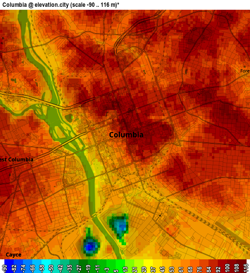
Below is the Elevation map of Columbia, which displays elevation range with different colors. Scale of the first map is from -90 to 116 m (-295 to 381 ft) with average elevation of 72.9 meters (=239 ft) [note 1]
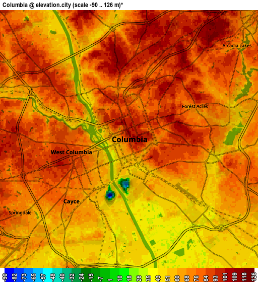
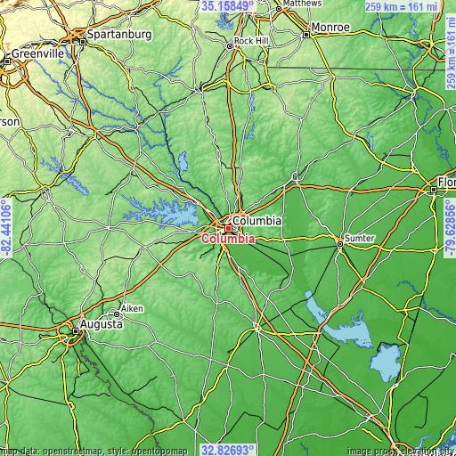
These maps also provides idea of topography and contour of this city, they are displayed at different zoom levels. More info about maps, scale and edge coordinates you can find below images.
| \ | Map #1 | Map #2 | Topo.Map |
| Scale [m] | -90..116 m | -90..126 m | × |
| Scale [ft] | -295..381 ft | -295..413 ft | × |
| Average | 72.9 m = 239 ft | 70.6 m = 232 ft | × |
| Width | 8.1 km = 5 mi | 16.2 km = 10.1 mi | 259.2 km = 161.1 mi |
| Height | 8.1 km = 5 mi | 16.2 km = 10.1 mi | 259.2 km = 161.1 mi |
| ↑Max Latitude | 34.037134° | 34.073543° | 35.15849° |
| Latitude at center | 34.00071° | 34.00071° | 34.00071° |
| ↓Min Latitude | 33.96427° | 33.927815° | 32.82693° |
| ← Min Longitude | -81.078755° | -81.122701° | -82.44106° |
| Longitude center | -81.03481° | -81.03481° | -81.03481° |
| →Max Longitude | -80.990865° | -80.946919° | -79.62856° |
Nearby cities:
Cities around Columbia sort by population:
• Saint Andrews elevation 92 m
10 km,  299°
299°
• West Columbia 87 m
3.7 km,  257°
257°
• Seven Oaks 73 m
11.6 km, 297°
• Dentsville 69 m
10 km,  45°
45°
• Cayce 78 m
5.3 km,  222°
222°
• Irmo 107 m
16.6 km, 304°
• Forest Acres 76 m
4.6 km,  63°
63°
• Oak Grove 111 m
10.2 km, 257°
• Woodfield 102 m
11.6 km, 55°
• Springdale 74 m
8.2 km,  236°
236°
• South Congaree 60 m
13.6 km, 222°
• Pineridge 85 m
11.9 km,  212°
212°
Multilingual:
 En español:
Columbia elevación 97 m.
 En France:
Columbia élévation 97 m.


Sources and notes:
- [note 1] Map square and city borders are not equal. Map elevation data is calculated only from area inside that square.
- [src 1] Elevation data from geonames database provided with same terms of usage.
- [src 2] The elevation map of Columbia is generated using elevation data from NASA's 3 arcsec (90m) resolution SRTM data.
- [src 3] Base (background) map © OpenStreetMap contributors tiles are generated by Geofabrik and OpenTopoMap.
Copyright & License:
This Columbia Elevation Map is licensed under CC BY-SA. You may reuse any part from this page, if you give a proper credit by linking to this URL:
 More info on terms of use page.