Georgetown elevation
Georgetown (Pennsylvania, Lancaster County), United States elevation is 207 meters and Georgetown elevation in feet is 679 ft above sea level [src 1]. Georgetown is a populated place (feature code) with elevation that is 72 meters (236 ft) smaller than average city elevation in United States.
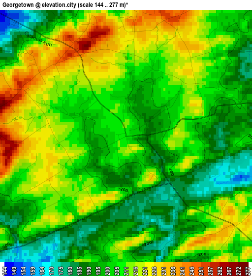
Below is the Elevation map of Georgetown, which displays elevation range with different colors. Scale of the first map is from 144 to 277 m (472 to 909 ft) with average elevation of 206.5 meters (=677 ft) [note 1]
These maps also provides idea of topography and contour of this city, they are displayed at different zoom levels. More info about maps, scale and edge coordinates you can find below images.
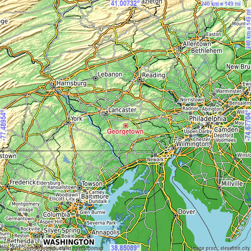
| \ | Map #1 | Topo.Map |
| Scale [m] | 144..277 m | × |
| Scale [ft] | 472..909 ft | × |
| Average | 206.5 m = 677 ft | × |
| Width | 7.49 km = 4.7 mi | 239.8 km = 149 mi |
| Height | 7.49 km = 4.7 mi | 239.8 km = 149 mi |
| ↑Max Latitude | 39.971287° | 41.00732° |
| Latitude at center | 39.9376° | 39.9376° |
| ↓Min Latitude | 39.903897° | 38.85089° |
| ← Min Longitude | -76.127235° | -77.48954° |
| Longitude center | -76.08329° | -76.08329° |
| →Max Longitude | -76.039345° | -74.67704° |
Nearby cities:
Cities around Georgetown sort by population:
• Willow Street elevation 150 m
17.1 km,  285°
285°
• Leola 133 m
18.8 km,  332°
332°
• New Holland 151 m
18.3 km,  359°
359°
• Parkesburg 165 m
14.2 km,  80°
80°
• Strasburg 146 m
10 km,  300°
300°
• Quarryville 153 m
8.2 km,  236°
236°
• Gap 168 m
7.7 km,  44°
44°
• Lampeter 129 m
14.6 km, 293°
• Atglen 149 m
9.4 km, 82°
• Intercourse 134 m
11.3 km,  350°
350°
• Christiana 147 m
7.6 km, 75°
• Paradise 114 m
8.9 km, 334°
Multilingual:
 En español:
Georgetown elevación 207 m.
 En France:
Georgetown élévation 207 m.
 Auf Deutsch:
Georgetown höhe über dem Meeresspiegel ist 207 m.

Sources and notes:
- [note 1] Map square and city borders are not equal. Map elevation data is calculated only from area inside that square.
- [src 1] Elevation data from geonames database provided with same terms of usage.
- [src 2] The elevation map of Georgetown is generated using elevation data from NASA's 3 arcsec (90m) resolution SRTM data.
- [src 3] Base (background) map © OpenStreetMap contributors tiles are generated by Geofabrik and OpenTopoMap.
Copyright & License:
This Georgetown Elevation Map is licensed under CC BY-SA. You may reuse any part from this page, if you give a proper credit by linking to this URL:
 More info on terms of use page.