Hartshorne elevation
Hartshorne (Oklahoma, Pittsburg County), United States elevation is 220 meters and Hartshorne elevation in feet is 722 ft above sea level [src 1]. Hartshorne is a populated place (feature code) with elevation that is 59 meters (194 ft) smaller than average city elevation in United States.
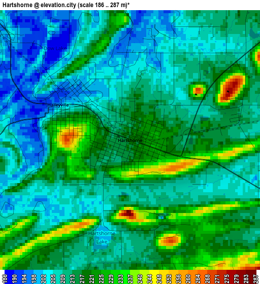
Below is the Elevation map of Hartshorne, which displays elevation range with different colors. Scale of the first map is from 186 to 287 m (610 to 942 ft) with average elevation of 213.4 meters (=700 ft) [note 1]
These maps also provides idea of topography and contour of this city, they are displayed at different zoom levels. More info about maps, scale and edge coordinates you can find below images.
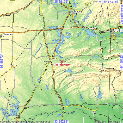
| \ | Map #1 | Topo.Map |
| Scale [m] | 186..287 m | × |
| Scale [ft] | 610..942 ft | × |
| Average | 213.4 m = 700 ft | × |
| Width | 8.02 km = 5 mi | 256.6 km = 159.4 mi |
| Height | 8.02 km = 5 mi | 256.6 km = 159.4 mi |
| ↑Max Latitude | 34.881158° | 35.99108° |
| Latitude at center | 34.8451° | 34.8451° |
| ↓Min Latitude | 34.809026° | 33.68294° |
| ← Min Longitude | -95.601425° | -96.96373° |
| Longitude center | -95.55748° | -95.55748° |
| →Max Longitude | -95.513535° | -94.15123° |
Nearby cities:
Cities around Hartshorne sort by population:
• McAlester elevation 225 m
21.7 km,  296°
296°
• Checotah 201 m
69.6 km,  2°
2°
• Eufaula 192 m
49.2 km,  357°
357°
• Stigler 180 m
60.2 km,  41°
41°
• Longtown 193 m
44.7 km,  5°
5°
• Wilburton 206 m
24.1 km,  70°
70°
• Antlers 161 m
68.5 km,  184°
184°
• Texanna 187 m
56.9 km, 11°
• Krebs 206 m
17.1 km, 302°
• Coalgate 193 m
69.4 km,  240°
240°
• Talihina 213 m
47.7 km,  102°
102°
• Quinton 188 m
35.2 km,  28°
28°
Multilingual:
 En español:
Hartshorne elevación 220 m.
 En France:
Hartshorne élévation 220 m.
 Auf Deutsch:
Hartshorne höhe über dem Meeresspiegel ist 220 m.

Sources and notes:
- [note 1] Map square and city borders are not equal. Map elevation data is calculated only from area inside that square.
- [src 1] Elevation data from geonames database provided with same terms of usage.
- [src 2] The elevation map of Hartshorne is generated using elevation data from NASA's 3 arcsec (90m) resolution SRTM data.
- [src 3] Base (background) map © OpenStreetMap contributors tiles are generated by Geofabrik and OpenTopoMap.
Copyright & License:
This Hartshorne Elevation Map is licensed under CC BY-SA. You may reuse any part from this page, if you give a proper credit by linking to this URL:
 More info on terms of use page.