Texanna elevation
Texanna (Oklahoma, McIntosh County), United States elevation is 187 meters and Texanna elevation in feet is 614 ft above sea level [src 1]. Texanna is a populated place (feature code) with elevation that is 92 meters (302 ft) smaller than average city elevation in United States.
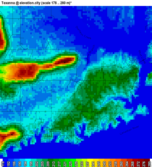
Below is the Elevation map of Texanna, which displays elevation range with different colors. Scale of the first map is from 178 to 280 m (584 to 919 ft) with average elevation of 193.9 meters (=636 ft) [note 1]
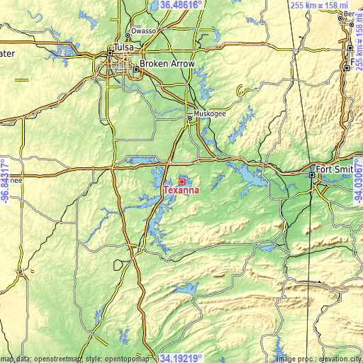
These maps also provides idea of topography and contour of this city, they are displayed at different zoom levels. More info about maps, scale and edge coordinates you can find below images.
| \ | Map #1 | Topo.Map |
| Scale [m] | 178..280 m | × |
| Scale [ft] | 584..919 ft | × |
| Average | 193.9 m = 636 ft | × |
| Width | 7.97 km = 5 mi | 255.1 km = 158.5 mi |
| Height | 7.97 km = 5 mi | 255.1 km = 158.5 mi |
| ↑Max Latitude | 35.383156° | 36.48616° |
| Latitude at center | 35.34732° | 35.34732° |
| ↓Min Latitude | 35.311468° | 34.19219° |
| ← Min Longitude | -95.480865° | -96.84317° |
| Longitude center | -95.43692° | -95.43692° |
| →Max Longitude | -95.392975° | -94.03067° |
Nearby cities:
Cities around Texanna sort by population:
• Muskogee elevation 191 m
45 km,  7°
7°
• Henryetta 211 m
50.5 km,  281°
281°
• Fort Gibson 173 m
52.8 km,  18°
18°
• Checotah 201 m
15.7 km,  330°
330°
• Eufaula 192 m
14.8 km,  243°
243°
• Stigler 180 m
30.3 km,  110°
110°
• Longtown 193 m
13.3 km,  211°
211°
• Wilburton 206 m
49.1 km,  166°
166°
• Warner 176 m
20.2 km,  36°
36°
• Morris 224 m
48 km,  307°
307°
• Vian 171 m
45.5 km,  68°
68°
• Quinton 188 m
25.7 km, 166°
Multilingual:
 En español:
Texanna elevación 187 m.
 En France:
Texanna élévation 187 m.


Sources and notes:
- [note 1] Map square and city borders are not equal. Map elevation data is calculated only from area inside that square.
- [src 1] Elevation data from geonames database provided with same terms of usage.
- [src 2] The elevation map of Texanna is generated using elevation data from NASA's 3 arcsec (90m) resolution SRTM data.
- [src 3] Base (background) map © OpenStreetMap contributors tiles are generated by Geofabrik and OpenTopoMap.
Copyright & License:
This Texanna Elevation Map is licensed under CC BY-SA. You may reuse any part from this page, if you give a proper credit by linking to this URL:
 More info on terms of use page.