Muskogee elevation
Muskogee (Oklahoma, Muskogee County), United States elevation is 191 meters and Muskogee elevation in feet is 627 ft above sea level [src 1]. Muskogee is a seat of a second-order administrative division (feature code) with elevation that is 88 meters (289 ft) smaller than average city elevation in United States.
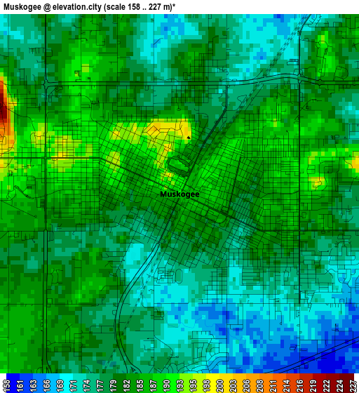
Below is the Elevation map of Muskogee, which displays elevation range with different colors. Scale of the first map is from 158 to 227 m (518 to 745 ft) with average elevation of 179.7 meters (=590 ft) [note 1]
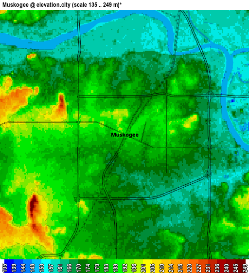
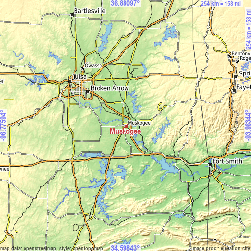
These maps also provides idea of topography and contour of this city, they are displayed at different zoom levels. More info about maps, scale and edge coordinates you can find below images.
| \ | Map #1 | Map #2 | Topo.Map |
| Scale [m] | 158..227 m | 135..249 m | × |
| Scale [ft] | 518..745 ft | 443..817 ft | × |
| Average | 179.7 m = 590 ft | 175.6 m = 576 ft | × |
| Width | 7.93 km = 4.9 mi | 15.86 km = 9.9 mi | 253.8 km = 157.7 mi |
| Height | 7.93 km = 4.9 mi | 15.86 km = 9.9 mi | 253.8 km = 157.7 mi |
| ↑Max Latitude | 35.783538° | 35.81918° | 36.88097° |
| Latitude at center | 35.74788° | 35.74788° | 35.74788° |
| ↓Min Latitude | 35.712206° | 35.676516° | 34.59843° |
| ← Min Longitude | -95.413635° | -95.457581° | -96.77594° |
| Longitude center | -95.36969° | -95.36969° | -95.36969° |
| →Max Longitude | -95.325745° | -95.281799° | -93.96344° |
Nearby cities:
Cities around Muskogee sort by population:
• Tahlequah elevation 249 m
40.6 km,  62°
62°
• Coweta 205 m
34 km,  311°
311°
• Wagoner 187 m
23.5 km,  0°
0°
• Fort Gibson 173 m
12.1 km, 62°
• Park Hill 228 m
39.1 km,  71°
71°
• Checotah 201 m
33.9 km,  204°
204°
• Texanna 187 m
45 km,  187°
187°
• Haskell 179 m
28.6 km,  286°
286°
• Inola 188 m
46.6 km,  344°
344°
• Warner 176 m
28.8 km,  168°
168°
• Morris 224 m
47 km,  250°
250°
• Vian 171 m
45.6 km,  127°
127°
Multilingual:
 En español:
Muskogee elevación 191 m.
 En France:
Muskogee élévation 191 m.
 Auf Deutsch:
Muskogee höhe über dem Meeresspiegel ist 191 m.

Sources and notes:
- [note 1] Map square and city borders are not equal. Map elevation data is calculated only from area inside that square.
- [src 1] Elevation data from geonames database provided with same terms of usage.
- [src 2] The elevation map of Muskogee is generated using elevation data from NASA's 3 arcsec (90m) resolution SRTM data.
- [src 3] Base (background) map © OpenStreetMap contributors tiles are generated by Geofabrik and OpenTopoMap.
Copyright & License:
This Muskogee Elevation Map is licensed under CC BY-SA. You may reuse any part from this page, if you give a proper credit by linking to this URL:
 More info on terms of use page.