Colbert elevation
Colbert (Oklahoma, Bryan County), United States elevation is 205 meters and Colbert elevation in feet is 673 ft above sea level [src 1]. Colbert is a populated place (feature code) with elevation that is 74 meters (243 ft) smaller than average city elevation in United States.
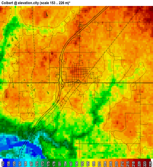
Below is the Elevation map of Colbert, which displays elevation range with different colors. Scale of the first map is from 153 to 226 m (502 to 741 ft) with average elevation of 198.6 meters (=652 ft) [note 1]
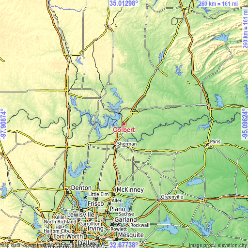
These maps also provides idea of topography and contour of this city, they are displayed at different zoom levels. More info about maps, scale and edge coordinates you can find below images.
| \ | Map #1 | Topo.Map |
| Scale [m] | 153..226 m | × |
| Scale [ft] | 502..741 ft | × |
| Average | 198.6 m = 652 ft | × |
| Width | 8.12 km = 5 mi | 259.7 km = 161.4 mi |
| Height | 8.12 km = 5 mi | 259.7 km = 161.4 mi |
| ↑Max Latitude | 33.889647° | 35.01298° |
| Latitude at center | 33.85316° | 33.85316° |
| ↓Min Latitude | 33.816657° | 32.67738° |
| ← Min Longitude | -96.546435° | -97.90874° |
| Longitude center | -96.50249° | -96.50249° |
| →Max Longitude | -96.458545° | -95.09624° |
Nearby cities:
Cities around Colbert sort by population:
• Sherman elevation 231 m
26.1 km,  202°
202°
• Denison 227 m
11.3 km, 196°
• Durant 199 m
19.8 km,  37°
37°
• Madill 244 m
36.2 km,  316°
316°
• Pottsboro 238 m
18.6 km,  235°
235°
• Calera 220 m
11.3 km, 37°
• Preston 213 m
12.5 km,  285°
285°
• Kingston 246 m
25.8 km,  308°
308°
• Bells 217 m
28.3 km,  162°
162°
• Sherwood Shores 220 m
29.1 km,  269°
269°
• Tom Bean 253 m
37.1 km,  177°
177°
• Southmayd 226 m
35 km,  224°
224°
Multilingual:
 En español:
Colbert elevación 205 m.
 En France:
Colbert élévation 205 m.


Sources and notes:
- [note 1] Map square and city borders are not equal. Map elevation data is calculated only from area inside that square.
- [src 1] Elevation data from geonames database provided with same terms of usage.
- [src 2] The elevation map of Colbert is generated using elevation data from NASA's 3 arcsec (90m) resolution SRTM data.
- [src 3] Base (background) map © OpenStreetMap contributors tiles are generated by Geofabrik and OpenTopoMap.
Copyright & License:
This Colbert Elevation Map is licensed under CC BY-SA. You may reuse any part from this page, if you give a proper credit by linking to this URL:
 More info on terms of use page.