Sherman elevation
Sherman (Texas, Grayson County), United States elevation is 231 meters and Sherman elevation in feet is 758 ft above sea level [src 1]. Sherman is a seat of a second-order administrative division (feature code) with elevation that is 48 meters (157 ft) smaller than average city elevation in United States.
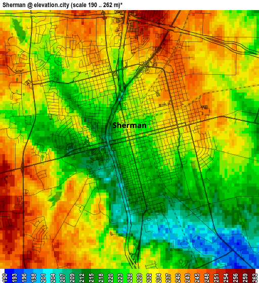
Below is the Elevation map of Sherman, which displays elevation range with different colors. Scale of the first map is from 190 to 262 m (623 to 860 ft) with average elevation of 229.5 meters (=753 ft) [note 1]
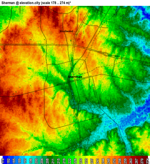
These maps also provides idea of topography and contour of this city, they are displayed at different zoom levels. More info about maps, scale and edge coordinates you can find below images.
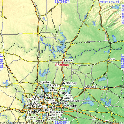
| \ | Map #1 | Map #2 | Topo.Map |
| Scale [m] | 190..262 m | 178..274 m | × |
| Scale [ft] | 623..860 ft | 584..899 ft | × |
| Average | 229.5 m = 753 ft | 229.5 m = 753 ft | × |
| Width | 8.14 km = 5.1 mi | 16.27 km = 10.1 mi | 260.4 km = 161.8 mi |
| Height | 8.14 km = 5.1 mi | 16.27 km = 10.1 mi | 260.4 km = 161.8 mi |
| ↑Max Latitude | 33.67224° | 33.708805° | 34.79847° |
| Latitude at center | 33.63566° | 33.63566° | 33.63566° |
| ↓Min Latitude | 33.599064° | 33.562453° | 32.45694° |
| ← Min Longitude | -96.652825° | -96.696771° | -98.01513° |
| Longitude center | -96.60888° | -96.60888° | -96.60888° |
| →Max Longitude | -96.564935° | -96.520989° | -95.20263° |
Nearby cities:
Cities around Sherman sort by population:
• Denison elevation 227 m
14.9 km,  26°
26°
• Whitesboro 252 m
27.7 km,  274°
274°
• Van Alstyne 240 m
24 km,  172°
172°
• Howe 260 m
14.1 km,  181°
181°
• Pottsboro 238 m
14.8 km,  337°
337°
• Preston 213 m
27.5 km,  355°
355°
• Whitewright 235 m
24.3 km,  124°
124°
• Bells 217 m
18.6 km,  98°
98°
• Gunter 217 m
24.5 km,  211°
211°
• Colbert 205 m
26.1 km,  22°
22°
• Tom Bean 253 m
17.3 km,  137°
137°
• Southmayd 226 m
14.8 km, 267°
Multilingual:
 En español:
Sherman elevación 231 m.
 En France:
Sherman élévation 231 m.


Sources and notes:
- [note 1] Map square and city borders are not equal. Map elevation data is calculated only from area inside that square.
- [src 1] Elevation data from geonames database provided with same terms of usage.
- [src 2] The elevation map of Sherman is generated using elevation data from NASA's 3 arcsec (90m) resolution SRTM data.
- [src 3] Base (background) map © OpenStreetMap contributors tiles are generated by Geofabrik and OpenTopoMap.
Copyright & License:
This Sherman Elevation Map is licensed under CC BY-SA. You may reuse any part from this page, if you give a proper credit by linking to this URL:
 More info on terms of use page.