Altus elevation
Altus (Oklahoma, Jackson County), United States elevation is 430 meters and Altus elevation in feet is 1411 ft above sea level [src 1]. Altus is a seat of a second-order administrative division (feature code) with elevation that is 151 meters (495 ft) bigger than average city elevation in United States.
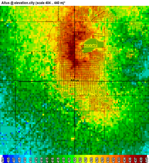
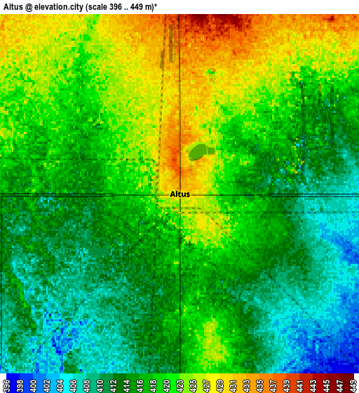
Below is the Elevation map of Altus, which displays elevation range with different colors. Scale of the first map is from 404 to 440 m (1325 to 1444 ft) with average elevation of 420.9 meters (=1381 ft) [note 1]
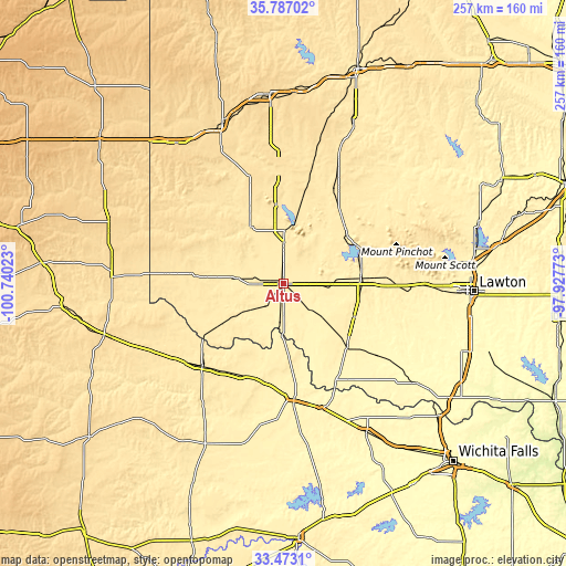
These maps also provides idea of topography and contour of this city, they are displayed at different zoom levels. More info about maps, scale and edge coordinates you can find below images.
| \ | Map #1 | Map #2 | Topo.Map |
| Scale [m] | 404..440 m | 396..449 m | × |
| Scale [ft] | 1325..1444 ft | 1299..1473 ft | × |
| Average | 420.9 m = 1381 ft | 418 m = 1371 ft | × |
| Width | 8.04 km = 5 mi | 16.08 km = 10 mi | 257.3 km = 159.9 mi |
| Height | 8.04 km = 5 mi | 16.08 km = 10 mi | 257.3 km = 159.9 mi |
| ↑Max Latitude | 34.674278° | 34.710411° | 35.78702° |
| Latitude at center | 34.63813° | 34.63813° | 34.63813° |
| ↓Min Latitude | 34.601966° | 34.565786° | 33.4731° |
| ← Min Longitude | -99.377925° | -99.421871° | -100.74023° |
| Longitude center | -99.33398° | -99.33398° | -99.33398° |
| →Max Longitude | -99.290035° | -99.246089° | -97.92773° |
Nearby cities:
Cities around Altus sort by population:
• Vernon elevation 361 m
54 km,  173°
173°
• Sayre 554 m
77.8 km,  338°
338°
• Frederick 402 m
39.8 km,  133°
133°
• Hobart 477 m
48.8 km,  26°
26°
• Cache 392 m
64.5 km,  90°
90°
• Mangum 492 m
30.3 km,  329°
329°
• Cordell 481 m
79.1 km,  23°
23°
• Electra 378 m
77.7 km,  150°
150°
• Quanah 486 m
53.1 km,  224°
224°
• Granite 497 m
36.3 km,  353°
353°
• Hollis 501 m
53.2 km,  276°
276°
• Snyder 417 m
35 km, 86°
Multilingual:
 En español:
Altus elevación 430 m.
 En France:
Altus élévation 430 m.


Sources and notes:
- [note 1] Map square and city borders are not equal. Map elevation data is calculated only from area inside that square.
- [src 1] Elevation data from geonames database provided with same terms of usage.
- [src 2] The elevation map of Altus is generated using elevation data from NASA's 3 arcsec (90m) resolution SRTM data.
- [src 3] Base (background) map © OpenStreetMap contributors tiles are generated by Geofabrik and OpenTopoMap.
Copyright & License:
This Altus Elevation Map is licensed under CC BY-SA. You may reuse any part from this page, if you give a proper credit by linking to this URL:
 More info on terms of use page.