Middletown elevation
Middletown (Ohio, Butler County), United States elevation is 200 meters and Middletown elevation in feet is 656 ft above sea level [src 1]. Middletown is a populated place (feature code) with elevation that is 79 meters (259 ft) smaller than average city elevation in United States.
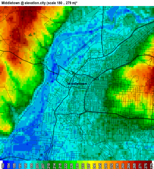
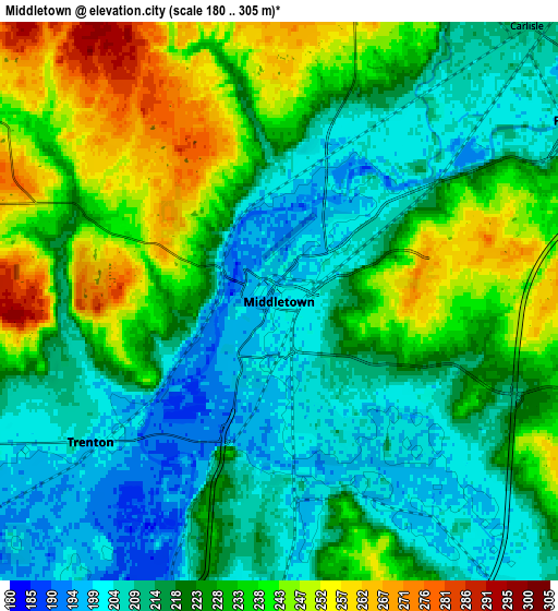
Below is the Elevation map of Middletown, which displays elevation range with different colors. Scale of the first map is from 180 to 279 m (591 to 915 ft) with average elevation of 213 meters (=699 ft) [note 1]
These maps also provides idea of topography and contour of this city, they are displayed at different zoom levels. More info about maps, scale and edge coordinates you can find below images.
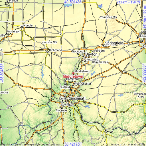
| \ | Map #1 | Map #2 | Topo.Map |
| Scale [m] | 180..279 m | 180..305 m | × |
| Scale [ft] | 591..915 ft | 591..1001 ft | × |
| Average | 213 m = 699 ft | 223.7 m = 734 ft | × |
| Width | 7.54 km = 4.7 mi | 15.08 km = 9.4 mi | 241.2 km = 149.9 mi |
| Height | 7.54 km = 4.7 mi | 15.08 km = 9.4 mi | 241.2 km = 149.9 mi |
| ↑Max Latitude | 39.548954° | 39.582831° | 40.59143° |
| Latitude at center | 39.51506° | 39.51506° | 39.51506° |
| ↓Min Latitude | 39.48115° | 39.447223° | 38.42175° |
| ← Min Longitude | -84.442225° | -84.486171° | -85.80453° |
| Longitude center | -84.39828° | -84.39828° | -84.39828° |
| →Max Longitude | -84.354335° | -84.310389° | -82.99203° |
Nearby cities:
Cities around Middletown sort by population:
• Miamisburg elevation 215 m
17.1 km,  33°
33°
• Springboro 239 m
14.7 km,  73°
73°
• Monroe 253 m
8.9 km,  159°
159°
• Trenton 198 m
6.4 km,  233°
233°
• Franklin 208 m
9.4 km,  58°
58°
• Germantown 220 m
12.6 km,  11°
11°
• Carlisle 211 m
10 km,  41°
41°
• Mayfield 207 m
3.1 km,  135°
135°
• New Miami 182 m
14.9 km, 233°
• Hunter 270 m
9.6 km,  104°
104°
• Wetherington 261 m
16.9 km,  173°
173°
• Farmersville 266 m
18.5 km,  351°
351°
Multilingual:
 En español:
Middletown elevación 200 m.
 En France:
Middletown élévation 200 m.
 Auf Deutsch:
Middletown höhe über dem Meeresspiegel ist 200 m.

Sources and notes:
- [note 1] Map square and city borders are not equal. Map elevation data is calculated only from area inside that square.
- [src 1] Elevation data from geonames database provided with same terms of usage.
- [src 2] The elevation map of Middletown is generated using elevation data from NASA's 3 arcsec (90m) resolution SRTM data.
- [src 3] Base (background) map © OpenStreetMap contributors tiles are generated by Geofabrik and OpenTopoMap.
Copyright & License:
This Middletown Elevation Map is licensed under CC BY-SA. You may reuse any part from this page, if you give a proper credit by linking to this URL:
 More info on terms of use page.