Canal Winchester elevation
Canal Winchester (Ohio, Franklin County), United States elevation is 233 meters and Canal Winchester elevation in feet is 764 ft above sea level [src 1]. Canal Winchester is a populated place (feature code) with elevation that is 46 meters (151 ft) smaller than average city elevation in United States.
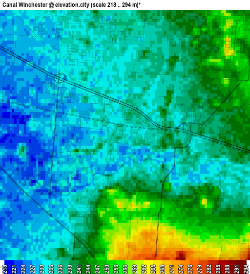
Below is the Elevation map of Canal Winchester, which displays elevation range with different colors. Scale of the first map is from 218 to 294 m (715 to 965 ft) with average elevation of 237.4 meters (=779 ft) [note 1]
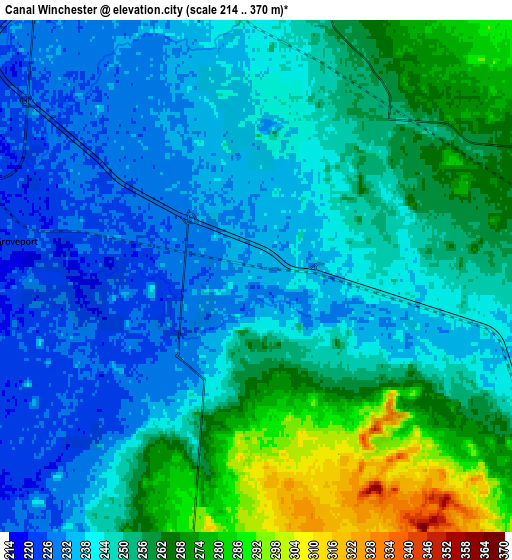
These maps also provides idea of topography and contour of this city, they are displayed at different zoom levels. More info about maps, scale and edge coordinates you can find below images.
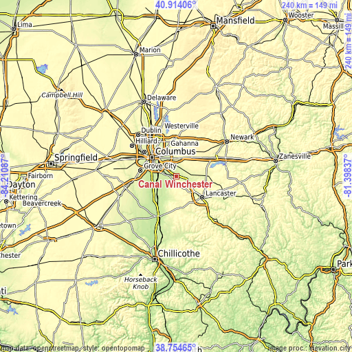
| \ | Map #1 | Map #2 | Topo.Map |
| Scale [m] | 218..294 m | 214..370 m | × |
| Scale [ft] | 715..965 ft | 702..1214 ft | × |
| Average | 237.4 m = 779 ft | 249 m = 817 ft | × |
| Width | 7.5 km = 4.7 mi | 15.01 km = 9.3 mi | 240.1 km = 149.2 mi |
| Height | 7.5 km = 4.7 mi | 15.01 km = 9.3 mi | 240.1 km = 149.2 mi |
| ↑Max Latitude | 39.876573° | 39.91029° | 40.91406° |
| Latitude at center | 39.84284° | 39.84284° | 39.84284° |
| ↓Min Latitude | 39.80909° | 39.775324° | 38.75465° |
| ← Min Longitude | -82.848565° | -82.892511° | -84.21087° |
| Longitude center | -82.80462° | -82.80462° | -82.80462° |
| →Max Longitude | -82.760675° | -82.716729° | -81.39837° |
Nearby cities:
Cities around Canal Winchester sort by population:
• Reynoldsburg elevation 266 m
12.5 km,  357°
357°
• Pickerington 252 m
6.3 km,  43°
43°
• Whitehall 242 m
15.4 km,  333°
333°
• Pataskala 305 m
20.3 km,  33°
33°
• Bexley 243 m
18 km,  321°
321°
• Blacklick Estates 231 m
8.6 km, 323°
• Groveport 225 m
7.8 km,  300°
300°
• Obetz 227 m
13.1 km,  287°
287°
• Ashville 216 m
19 km,  221°
221°
• Baltimore 261 m
17.4 km,  89°
89°
• Lithopolis 287 m
4.4 km,  181°
181°
• Etna 321 m
16.5 km, 39°
Multilingual:
 En español:
Canal Winchester elevación 233 m.
 En France:
Canal Winchester élévation 233 m.
 Auf Deutsch:
Canal Winchester höhe über dem Meeresspiegel ist 233 m.

Sources and notes:
- [note 1] Map square and city borders are not equal. Map elevation data is calculated only from area inside that square.
- [src 1] Elevation data from geonames database provided with same terms of usage.
- [src 2] The elevation map of Canal Winchester is generated using elevation data from NASA's 3 arcsec (90m) resolution SRTM data.
- [src 3] Base (background) map © OpenStreetMap contributors tiles are generated by Geofabrik and OpenTopoMap.
Copyright & License:
This Canal Winchester Elevation Map is licensed under CC BY-SA. You may reuse any part from this page, if you give a proper credit by linking to this URL:
 More info on terms of use page.