Bexley elevation
Bexley (Ohio, Franklin County), United States elevation is 243 meters and Bexley elevation in feet is 797 ft above sea level [src 1]. Bexley is a populated place (feature code) with elevation that is 36 meters (118 ft) smaller than average city elevation in United States.
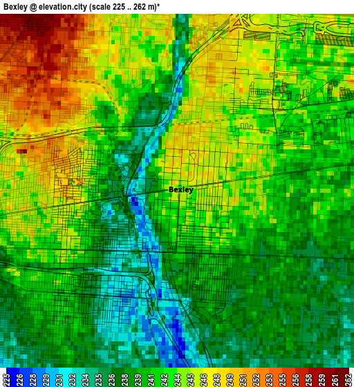
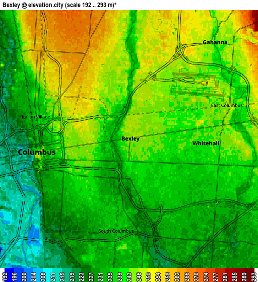
Below is the Elevation map of Bexley, which displays elevation range with different colors. Scale of the first map is from 225 to 262 m (738 to 860 ft) with average elevation of 241.8 meters (=793 ft) [note 1]
These maps also provides idea of topography and contour of this city, they are displayed at different zoom levels. More info about maps, scale and edge coordinates you can find below images.
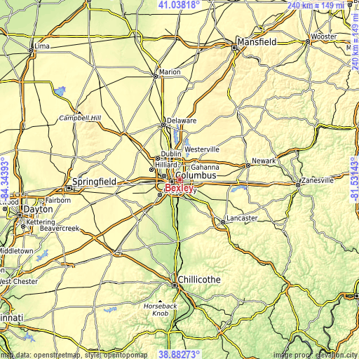
| \ | Map #1 | Map #2 | Topo.Map |
| Scale [m] | 225..262 m | 192..293 m | × |
| Scale [ft] | 738..860 ft | 630..961 ft | × |
| Average | 241.8 m = 793 ft | 239 m = 784 ft | × |
| Width | 7.49 km = 4.7 mi | 14.98 km = 9.3 mi | 239.7 km = 148.9 mi |
| Height | 7.49 km = 4.7 mi | 14.98 km = 9.3 mi | 239.7 km = 148.9 mi |
| ↑Max Latitude | 40.002621° | 40.036276° | 41.03818° |
| Latitude at center | 39.96895° | 39.96895° | 39.96895° |
| ↓Min Latitude | 39.935262° | 39.901558° | 38.88273° |
| ← Min Longitude | -82.981625° | -83.025571° | -84.34393° |
| Longitude center | -82.93768° | -82.93768° | -82.93768° |
| →Max Longitude | -82.893735° | -82.849789° | -81.53143° |
Nearby cities:
Cities around Bexley sort by population:
• Columbus elevation 242 m
5.3 km,  260°
260°
• Reynoldsburg 266 m
10.8 km,  98°
98°
• Upper Arlington 249 m
11 km,  284°
284°
• Gahanna 244 m
7.5 km,  41°
41°
• Whitehall 242 m
4.5 km,  93°
93°
• Blacklick Estates 231 m
9.5 km,  138°
138°
• Grandview Heights 239 m
8.9 km, 277°
• Groveport 225 m
11.1 km,  155°
155°
• Obetz 227 m
10.1 km,  186°
186°
• Huber Ridge 251 m
13.4 km,  7°
7°
• Minerva Park 265 m
12 km,  357°
357°
• Urbancrest 256 m
15 km,  238°
238°
Multilingual:
 En español:
Bexley elevación 243 m.
 En France:
Bexley élévation 243 m.


Sources and notes:
- [note 1] Map square and city borders are not equal. Map elevation data is calculated only from area inside that square.
- [src 1] Elevation data from geonames database provided with same terms of usage.
- [src 2] The elevation map of Bexley is generated using elevation data from NASA's 3 arcsec (90m) resolution SRTM data.
- [src 3] Base (background) map © OpenStreetMap contributors tiles are generated by Geofabrik and OpenTopoMap.
Copyright & License:
This Bexley Elevation Map is licensed under CC BY-SA. You may reuse any part from this page, if you give a proper credit by linking to this URL:
 More info on terms of use page.