Ashville elevation
Ashville (Ohio, Pickaway County), United States elevation is 216 meters and Ashville elevation in feet is 709 ft above sea level [src 1]. Ashville is a populated place (feature code) with elevation that is 63 meters (207 ft) smaller than average city elevation in United States.
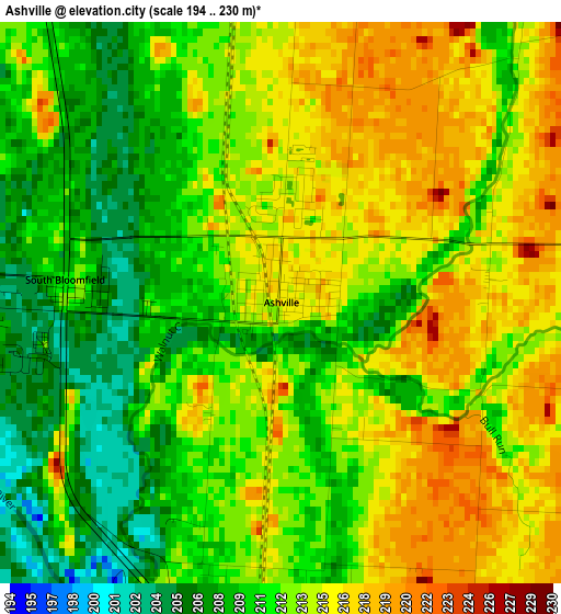
Below is the Elevation map of Ashville, which displays elevation range with different colors. Scale of the first map is from 194 to 230 m (636 to 755 ft) with average elevation of 212.5 meters (=697 ft) [note 1]
These maps also provides idea of topography and contour of this city, they are displayed at different zoom levels. More info about maps, scale and edge coordinates you can find below images.
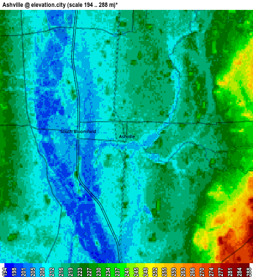
| \ | Map #1 | Map #2 | Topo.Map |
| Scale [m] | 194..230 m | 194..288 m | × |
| Scale [ft] | 636..755 ft | 636..945 ft | × |
| Average | 212.5 m = 697 ft | 218.4 m = 717 ft | × |
| Width | 7.52 km = 4.7 mi | 15.03 km = 9.3 mi | 240.5 km = 149.4 mi |
| Height | 7.52 km = 4.7 mi | 15.03 km = 9.3 mi | 240.5 km = 149.4 mi |
| ↑Max Latitude | 39.749416° | 39.783195° | 40.78884° |
| Latitude at center | 39.71562° | 39.71562° | 39.71562° |
| ↓Min Latitude | 39.681808° | 39.647979° | 38.62544° |
| ← Min Longitude | -82.996905° | -83.040851° | -84.35921° |
| Longitude center | -82.95296° | -82.95296° | -82.95296° |
| →Max Longitude | -82.909015° | -82.865069° | -81.54671° |
Nearby cities:
Cities around Ashville sort by population:
• Grove City elevation 258 m
22 km,  327°
327°
• Circleville 211 m
12.8 km,  177°
177°
• Blacklick Estates 231 m
22.4 km,  19°
19°
• Canal Winchester 233 m
19 km,  41°
41°
• Groveport 225 m
19 km, 18°
• Obetz 227 m
18.2 km,  0°
0°
• South Bloomfield 211 m
2.9 km,  276°
276°
• Commercial Point 239 m
10.7 km,  303°
303°
• Lithopolis 287 m
15.9 km,  52°
52°
• Logan Elm Village 213 m
16.2 km, 179°
• Williamsport 229 m
20.3 km,  224°
224°
• Urbancrest 256 m
23.2 km, 330°
Multilingual:
 En español:
Ashville elevación 216 m.
 En France:
Ashville élévation 216 m.
 Auf Deutsch:
Ashville höhe über dem Meeresspiegel ist 216 m.

Sources and notes:
- [note 1] Map square and city borders are not equal. Map elevation data is calculated only from area inside that square.
- [src 1] Elevation data from geonames database provided with same terms of usage.
- [src 2] The elevation map of Ashville is generated using elevation data from NASA's 3 arcsec (90m) resolution SRTM data.
- [src 3] Base (background) map © OpenStreetMap contributors tiles are generated by Geofabrik and OpenTopoMap.
Copyright & License:
This Ashville Elevation Map is licensed under CC BY-SA. You may reuse any part from this page, if you give a proper credit by linking to this URL:
 More info on terms of use page.