Barnesville elevation
Barnesville (Ohio, Belmont County), United States elevation is 390 meters and Barnesville elevation in feet is 1280 ft above sea level [src 1]. Barnesville is a populated place (feature code) with elevation that is 111 meters (364 ft) bigger than average city elevation in United States.
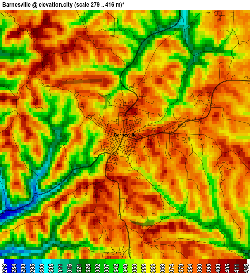
Below is the Elevation map of Barnesville, which displays elevation range with different colors. Scale of the first map is from 279 to 416 m (915 to 1365 ft) with average elevation of 367.6 meters (=1206 ft) [note 1]
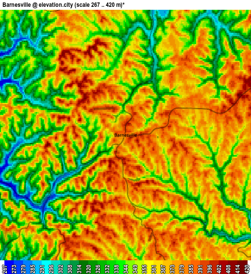
These maps also provides idea of topography and contour of this city, they are displayed at different zoom levels. More info about maps, scale and edge coordinates you can find below images.
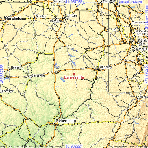
| \ | Map #1 | Map #2 | Topo.Map |
| Scale [m] | 279..416 m | 267..420 m | × |
| Scale [ft] | 915..1365 ft | 876..1378 ft | × |
| Average | 367.6 m = 1206 ft | 356.5 m = 1170 ft | × |
| Width | 7.49 km = 4.7 mi | 14.98 km = 9.3 mi | 239.6 km = 148.9 mi |
| Height | 7.49 km = 4.7 mi | 14.98 km = 9.3 mi | 239.6 km = 148.9 mi |
| ↑Max Latitude | 40.021792° | 40.055437° | 41.05705° |
| Latitude at center | 39.98813° | 39.98813° | 39.98813° |
| ↓Min Latitude | 39.954452° | 39.920757° | 38.90222° |
| ← Min Longitude | -81.220445° | -81.264391° | -82.58275° |
| Longitude center | -81.1765° | -81.1765° | -81.1765° |
| →Max Longitude | -81.132555° | -81.088609° | -79.77025° |
Nearby cities:
Cities around Barnesville sort by population:
• Cambridge elevation 252 m
35.4 km,  277°
277°
• Moundsville 211 m
37.7 km,  101°
101°
• Saint Clairsville 387 m
25.7 km,  66°
66°
• Bellaire 204 m
37.1 km,  85°
85°
• Shadyside 208 m
36.3 km, 93°
• Cadiz 385 m
35.2 km,  25°
25°
• Byesville 248 m
30.7 km,  266°
266°
• Woodsfield 367 m
25.6 km,  168°
168°
• Powhatan Point 205 m
33.9 km,  114°
114°
• Glendale 210 m
36.2 km, 96°
• Bethesda 374 m
9.4 km, 70°
• Wolfhurst 206 m
34.6 km, 74°
Multilingual:
 En español:
Barnesville elevación 390 m.
 En France:
Barnesville élévation 390 m.
 Auf Deutsch:
Barnesville höhe über dem Meeresspiegel ist 390 m.

Sources and notes:
- [note 1] Map square and city borders are not equal. Map elevation data is calculated only from area inside that square.
- [src 1] Elevation data from geonames database provided with same terms of usage.
- [src 2] The elevation map of Barnesville is generated using elevation data from NASA's 3 arcsec (90m) resolution SRTM data.
- [src 3] Base (background) map © OpenStreetMap contributors tiles are generated by Geofabrik and OpenTopoMap.
Copyright & License:
This Barnesville Elevation Map is licensed under CC BY-SA. You may reuse any part from this page, if you give a proper credit by linking to this URL:
 More info on terms of use page.