Cadiz elevation
Cadiz (Ohio, Harrison County), United States elevation is 385 meters and Cadiz elevation in feet is 1263 ft above sea level [src 1]. Cadiz is a seat of a second-order administrative division (feature code) with elevation that is 106 meters (348 ft) bigger than average city elevation in United States.
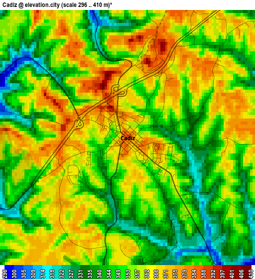
Below is the Elevation map of Cadiz, which displays elevation range with different colors. Scale of the first map is from 296 to 410 m (971 to 1345 ft) with average elevation of 354.3 meters (=1162 ft) [note 1]
These maps also provides idea of topography and contour of this city, they are displayed at different zoom levels. More info about maps, scale and edge coordinates you can find below images.
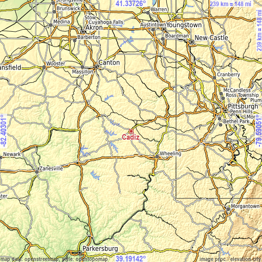
| \ | Map #1 | Topo.Map |
| Scale [m] | 296..410 m | × |
| Scale [ft] | 971..1345 ft | × |
| Average | 354.3 m = 1162 ft | × |
| Width | 7.46 km = 4.6 mi | 238.6 km = 148.3 mi |
| Height | 7.46 km = 4.6 mi | 238.6 km = 148.3 mi |
| ↑Max Latitude | 40.306371° | 41.33726° |
| Latitude at center | 40.27285° | 40.27285° |
| ↓Min Latitude | 40.239313° | 39.19142° |
| ← Min Longitude | -81.040705° | -82.40301° |
| Longitude center | -80.99676° | -80.99676° |
| →Max Longitude | -80.952815° | -79.59051° |
Nearby cities:
Cities around Cadiz sort by population:
• Steubenville elevation 318 m
32.6 km,  70°
70°
• Martins Ferry 216 m
30.4 km,  130°
130°
• Uhrichsville 263 m
32.5 km,  294°
294°
• Saint Clairsville 387 m
22.9 km,  158°
158°
• Wintersville 383 m
27.3 km, 65°
• Dennison 264 m
31.5 km,  295°
295°
• Bridgeport 198 m
31.4 km,  135°
135°
• Brilliant 203 m
31.5 km,  91°
91°
• Tiltonsville 204 m
27.8 km,  115°
115°
• Bethesda 374 m
29.3 km,  192°
192°
• Wolfhurst 206 m
29 km, 141°
• Yorkville 199 m
27.6 km, 118°
Multilingual:
 En español:
Cádiz elevación 385 m.
 En France:
Cadiz élévation 385 m.


Sources and notes:
- [note 1] Map square and city borders are not equal. Map elevation data is calculated only from area inside that square.
- [src 1] Elevation data from geonames database provided with same terms of usage.
- [src 2] The elevation map of Cadiz is generated using elevation data from NASA's 3 arcsec (90m) resolution SRTM data.
- [src 3] Base (background) map © OpenStreetMap contributors tiles are generated by Geofabrik and OpenTopoMap.
Copyright & License:
This Cadiz Elevation Map is licensed under CC BY-SA. You may reuse any part from this page, if you give a proper credit by linking to this URL:
 More info on terms of use page.