Rolesville elevation
Rolesville (North Carolina, Wake County), United States elevation is 136 meters and Rolesville elevation in feet is 446 ft above sea level [src 1]. Rolesville is a populated place (feature code) with elevation that is 143 meters (469 ft) smaller than average city elevation in United States.
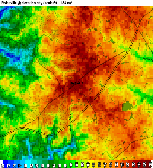
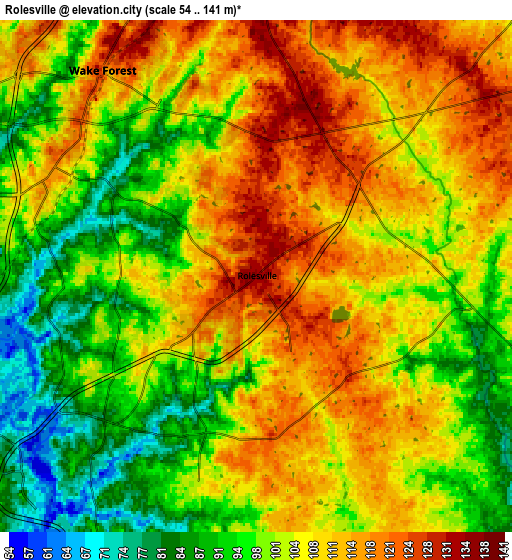
Below is the Elevation map of Rolesville, which displays elevation range with different colors. Scale of the first map is from 69 to 138 m (226 to 453 ft) with average elevation of 112.7 meters (=370 ft) [note 1]
These maps also provides idea of topography and contour of this city, they are displayed at different zoom levels. More info about maps, scale and edge coordinates you can find below images.
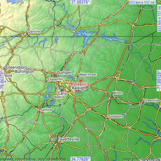
| \ | Map #1 | Map #2 | Topo.Map |
| Scale [m] | 69..138 m | 54..141 m | × |
| Scale [ft] | 226..453 ft | 177..463 ft | × |
| Average | 112.7 m = 370 ft | 104.3 m = 342 ft | × |
| Width | 7.91 km = 4.9 mi | 15.83 km = 9.8 mi | 253.2 km = 157.3 mi |
| Height | 7.91 km = 4.9 mi | 15.83 km = 9.8 mi | 253.2 km = 157.3 mi |
| ↑Max Latitude | 35.958789° | 35.994352° | 37.05376° |
| Latitude at center | 35.92321° | 35.92321° | 35.92321° |
| ↓Min Latitude | 35.887615° | 35.852004° | 34.77626° |
| ← Min Longitude | -78.501445° | -78.545391° | -79.86375° |
| Longitude center | -78.4575° | -78.4575° | -78.4575° |
| →Max Longitude | -78.413555° | -78.369609° | -77.05125° |
Nearby cities:
Cities around Rolesville sort by population:
• Raleigh elevation 99 m
23.4 km,  224°
224°
• West Raleigh 124 m
24 km,  230°
230°
• Wake Forest 120 m
7.9 km,  323°
323°
• Garner 113 m
27.5 km,  210°
210°
• Knightdale 97 m
15.2 km,  187°
187°
• Wendell 99 m
17.7 km,  153°
153°
• Zebulon 99 m
16.9 km,  130°
130°
• Archer Lodge 101 m
26.5 km,  163°
163°
• Creedmoor 116 m
30.2 km, 317°
• Louisburg 69 m
24.1 km,  35°
35°
• Franklinton 128 m
19.9 km,  359°
359°
• Youngsville 144 m
11.4 km,  352°
352°
Multilingual:
 En español:
Rolesville elevación 136 m.
 En France:
Rolesville élévation 136 m.
 Auf Deutsch:
Rolesville höhe über dem Meeresspiegel ist 136 m.

Sources and notes:
- [note 1] Map square and city borders are not equal. Map elevation data is calculated only from area inside that square.
- [src 1] Elevation data from geonames database provided with same terms of usage.
- [src 2] The elevation map of Rolesville is generated using elevation data from NASA's 3 arcsec (90m) resolution SRTM data.
- [src 3] Base (background) map © OpenStreetMap contributors tiles are generated by Geofabrik and OpenTopoMap.
Copyright & License:
This Rolesville Elevation Map is licensed under CC BY-SA. You may reuse any part from this page, if you give a proper credit by linking to this URL:
 More info on terms of use page.