Louisburg elevation
Louisburg (North Carolina, Franklin County), United States elevation is 69 meters and Louisburg elevation in feet is 226 ft above sea level [src 1]. Louisburg is a seat of a second-order administrative division (feature code) with elevation that is 210 meters (689 ft) smaller than average city elevation in United States.
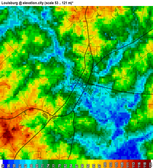
Below is the Elevation map of Louisburg, which displays elevation range with different colors. Scale of the first map is from 53 to 121 m (174 to 397 ft) with average elevation of 80.2 meters (=263 ft) [note 1]
These maps also provides idea of topography and contour of this city, they are displayed at different zoom levels. More info about maps, scale and edge coordinates you can find below images.
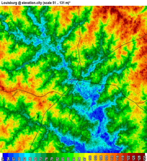
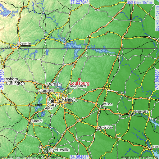
| \ | Map #1 | Map #2 | Topo.Map |
| Scale [m] | 53..121 m | 51..131 m | × |
| Scale [ft] | 174..397 ft | 167..430 ft | × |
| Average | 80.2 m = 263 ft | 87.6 m = 287 ft | × |
| Width | 7.9 km = 4.9 mi | 15.79 km = 9.8 mi | 252.7 km = 157 mi |
| Height | 7.9 km = 4.9 mi | 15.79 km = 9.8 mi | 252.7 km = 157 mi |
| ↑Max Latitude | 36.13454° | 36.170024° | 37.22704° |
| Latitude at center | 36.09904° | 36.09904° | 36.09904° |
| ↓Min Latitude | 36.063524° | 36.027992° | 34.95461° |
| ← Min Longitude | -78.345055° | -78.389001° | -79.70736° |
| Longitude center | -78.30111° | -78.30111° | -78.30111° |
| →Max Longitude | -78.257165° | -78.213219° | -76.89486° |
Nearby cities:
Cities around Louisburg sort by population:
• Wake Forest elevation 120 m
23 km,  234°
234°
• Henderson 153 m
27.1 km,  341°
341°
• Oxford 144 m
35.1 km,  312°
312°
• Rolesville 136 m
24.1 km,  215°
215°
• Nashville 57 m
33.2 km,  114°
114°
• Zebulon 99 m
30.6 km,  182°
182°
• Creedmoor 116 m
34.7 km,  274°
274°
• Franklinton 128 m
14.1 km, 271°
• Spring Hope 80 m
24.1 km,  135°
135°
• Youngsville 144 m
17.6 km,  242°
242°
• South Henderson 153 m
25.1 km, 337°
• Warrenton 118 m
35.8 km,  21°
21°
Multilingual:
 En español:
Louisburg elevación 69 m.
 En France:
Louisburg élévation 69 m.
 Auf Deutsch:
Louisburg höhe über dem Meeresspiegel ist 69 m.

Sources and notes:
- [note 1] Map square and city borders are not equal. Map elevation data is calculated only from area inside that square.
- [src 1] Elevation data from geonames database provided with same terms of usage.
- [src 2] The elevation map of Louisburg is generated using elevation data from NASA's 3 arcsec (90m) resolution SRTM data.
- [src 3] Base (background) map © OpenStreetMap contributors tiles are generated by Geofabrik and OpenTopoMap.
Copyright & License:
This Louisburg Elevation Map is licensed under CC BY-SA. You may reuse any part from this page, if you give a proper credit by linking to this URL:
 More info on terms of use page.