Oxford elevation
Oxford (North Carolina, Granville County), United States elevation is 144 meters and Oxford elevation in feet is 472 ft above sea level [src 1]. Oxford is a seat of a second-order administrative division (feature code) with elevation that is 135 meters (443 ft) smaller than average city elevation in United States.
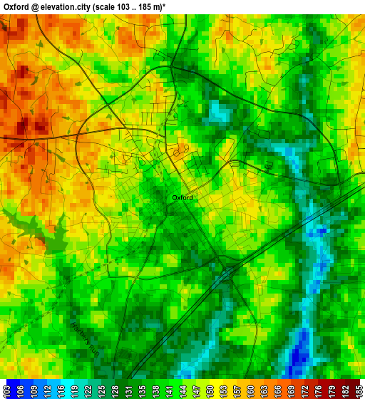
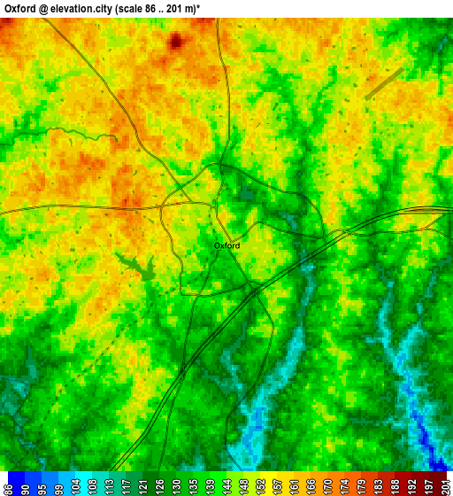
Below is the Elevation map of Oxford, which displays elevation range with different colors. Scale of the first map is from 103 to 185 m (338 to 607 ft) with average elevation of 143.4 meters (=470 ft) [note 1]
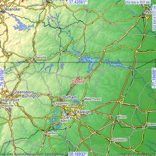
These maps also provides idea of topography and contour of this city, they are displayed at different zoom levels. More info about maps, scale and edge coordinates you can find below images.
| \ | Map #1 | Map #2 | Topo.Map |
| Scale [m] | 103..185 m | 86..201 m | × |
| Scale [ft] | 338..607 ft | 282..659 ft | × |
| Average | 143.4 m = 470 ft | 143.1 m = 469 ft | × |
| Width | 7.87 km = 4.9 mi | 15.75 km = 9.8 mi | 252 km = 156.6 mi |
| Height | 7.87 km = 4.9 mi | 15.75 km = 9.8 mi | 252 km = 156.6 mi |
| ↑Max Latitude | 36.346104° | 36.381492° | 37.43561° |
| Latitude at center | 36.3107° | 36.3107° | 36.3107° |
| ↓Min Latitude | 36.27528° | 36.239844° | 35.16932° |
| ← Min Longitude | -78.634775° | -78.678721° | -79.99708° |
| Longitude center | -78.59083° | -78.59083° | -78.59083° |
| →Max Longitude | -78.546885° | -78.502939° | -77.18458° |
Nearby cities:
Cities around Oxford sort by population:
• Wake Forest elevation 120 m
37.5 km,  168°
168°
• Henderson 153 m
17.3 km,  83°
83°
• Roxboro 220 m
36.3 km,  284°
284°
• Butner 113 m
24.8 km,  216°
216°
• Creedmoor 116 m
22.6 km,  202°
202°
• Louisburg 69 m
35.1 km,  132°
132°
• Franklinton 128 m
26.1 km,  152°
152°
• Youngsville 144 m
33.5 km,  161°
161°
• South Henderson 153 m
16.5 km,  90°
90°
• Clarksville 108 m
35 km,  4°
4°
• Norlina 130 m
38.2 km,  66°
66°
• Gorman 111 m
36.9 km,  214°
214°
Multilingual:
 En español:
Oxford elevación 144 m.
 En France:
Oxford élévation 144 m.


Sources and notes:
- [note 1] Map square and city borders are not equal. Map elevation data is calculated only from area inside that square.
- [src 1] Elevation data from geonames database provided with same terms of usage.
- [src 2] The elevation map of Oxford is generated using elevation data from NASA's 3 arcsec (90m) resolution SRTM data.
- [src 3] Base (background) map © OpenStreetMap contributors tiles are generated by Geofabrik and OpenTopoMap.
Copyright & License:
This Oxford Elevation Map is licensed under CC BY-SA. You may reuse any part from this page, if you give a proper credit by linking to this URL:
 More info on terms of use page.