Raleigh elevation
Raleigh (North Carolina, Wake County), United States elevation is 99 meters and Raleigh elevation in feet is 325 ft above sea level [src 1]. Raleigh is a seat of a first-order administrative division (feature code) with elevation that is 180 meters (591 ft) smaller than average city elevation in United States.
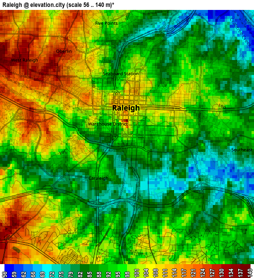
Below is the Elevation map of Raleigh, which displays elevation range with different colors. Scale of the first map is from 56 to 140 m (184 to 459 ft) with average elevation of 95.5 meters (=313 ft) [note 1]
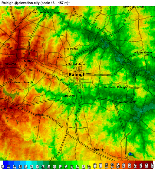
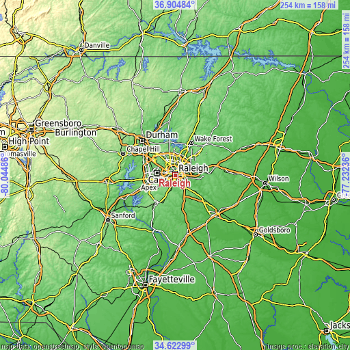
These maps also provides idea of topography and contour of this city, they are displayed at different zoom levels. More info about maps, scale and edge coordinates you can find below images.
| \ | Map #1 | Map #2 | Topo.Map |
| Scale [m] | 56..140 m | 16..157 m | × |
| Scale [ft] | 184..459 ft | 52..515 ft | × |
| Average | 95.5 m = 313 ft | 99.2 m = 325 ft | × |
| Width | 7.93 km = 4.9 mi | 15.86 km = 9.9 mi | 253.7 km = 157.6 mi |
| Height | 7.93 km = 4.9 mi | 15.86 km = 9.9 mi | 253.7 km = 157.6 mi |
| ↑Max Latitude | 35.807747° | 35.843378° | 36.90484° |
| Latitude at center | 35.7721° | 35.7721° | 35.7721° |
| ↓Min Latitude | 35.736437° | 35.700758° | 34.62299° |
| ← Min Longitude | -78.682555° | -78.726501° | -80.04486° |
| Longitude center | -78.63861° | -78.63861° | -78.63861° |
| →Max Longitude | -78.594665° | -78.550719° | -77.23236° |
Nearby cities:
Cities around Raleigh sort by population:
• West Raleigh elevation 124 m
2.8 km,  305°
305°
• Cary 152 m
13 km,  279°
279°
• Apex 153 m
19.6 km,  257°
257°
• Holly Springs 138 m
22.1 km,  232°
232°
• Garner 113 m
7.1 km,  161°
161°
• Morrisville 92 m
17.8 km,  288°
288°
• Clayton 103 m
21.3 km,  129°
129°
• Knightdale 97 m
14.4 km,  83°
83°
• Rolesville 136 m
23.4 km,  44°
44°
• Wendell 99 m
24.3 km,  87°
87°
• Scotts Mill 106 m
22.7 km, 257°
• Green Level 103 m
24 km,  272°
272°
Multilingual:
 En español:
Raleigh elevación 99 m.
 En France:
Raleigh élévation 99 m.


Sources and notes:
- [note 1] Map square and city borders are not equal. Map elevation data is calculated only from area inside that square.
- [src 1] Elevation data from geonames database provided with same terms of usage.
- [src 2] The elevation map of Raleigh is generated using elevation data from NASA's 3 arcsec (90m) resolution SRTM data.
- [src 3] Base (background) map © OpenStreetMap contributors tiles are generated by Geofabrik and OpenTopoMap.
Copyright & License:
This Raleigh Elevation Map is licensed under CC BY-SA. You may reuse any part from this page, if you give a proper credit by linking to this URL:
 More info on terms of use page.