Clayton elevation
Clayton (North Carolina, Johnston County), United States elevation is 103 meters and Clayton elevation in feet is 338 ft above sea level [src 1]. Clayton is a populated place (feature code) with elevation that is 176 meters (577 ft) smaller than average city elevation in United States.
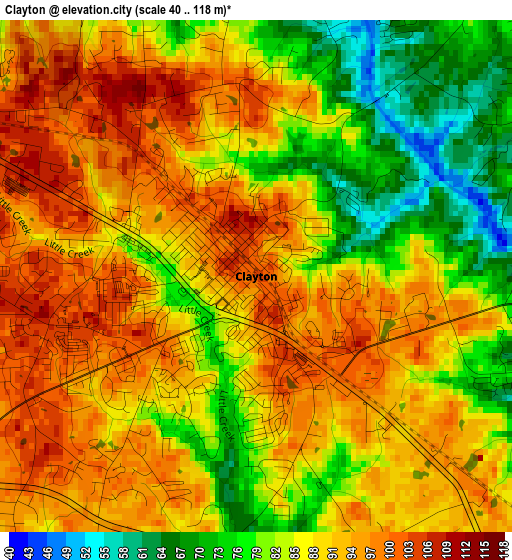
Below is the Elevation map of Clayton, which displays elevation range with different colors. Scale of the first map is from 40 to 118 m (131 to 387 ft) with average elevation of 87.7 meters (=288 ft) [note 1]
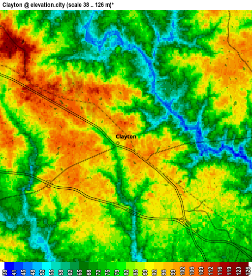
These maps also provides idea of topography and contour of this city, they are displayed at different zoom levels. More info about maps, scale and edge coordinates you can find below images.
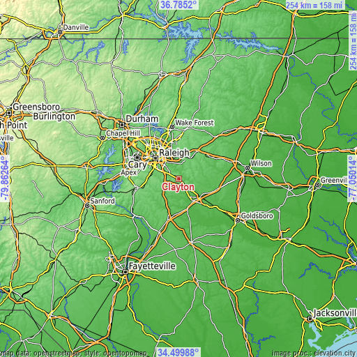
| \ | Map #1 | Map #2 | Topo.Map |
| Scale [m] | 40..118 m | 38..126 m | × |
| Scale [ft] | 131..387 ft | 125..413 ft | × |
| Average | 87.7 m = 288 ft | 82 m = 269 ft | × |
| Width | 7.94 km = 4.9 mi | 15.88 km = 9.9 mi | 254.1 km = 157.9 mi |
| Height | 7.94 km = 4.9 mi | 15.88 km = 9.9 mi | 254.1 km = 157.9 mi |
| ↑Max Latitude | 35.686411° | 35.722097° | 36.7852° |
| Latitude at center | 35.65071° | 35.65071° | 35.65071° |
| ↓Min Latitude | 35.614993° | 35.579259° | 34.49988° |
| ← Min Longitude | -78.500335° | -78.544281° | -79.86264° |
| Longitude center | -78.45639° | -78.45639° | -78.45639° |
| →Max Longitude | -78.412445° | -78.368499° | -77.05014° |
Nearby cities:
Cities around Clayton sort by population:
• Raleigh elevation 99 m
21.3 km,  309°
309°
• West Raleigh 124 m
24.1 km, 308°
• Garner 113 m
15.8 km,  295°
295°
• Knightdale 97 m
15.4 km,  351°
351°
• Smithfield 48 m
19 km,  146°
146°
• Selma 57 m
20.1 km,  129°
129°
• Wendell 99 m
16.5 km,  28°
28°
• Zebulon 99 m
23.2 km, 33°
• Archer Lodge 101 m
8.7 km,  56°
56°
• Wilsons Mills 71 m
11.7 km, 129°
• Four Oaks 61 m
23 km,  173°
173°
• Pine Level 52 m
24.5 km, 128°
Multilingual:
 En español:
Clayton elevación 103 m.
 En France:
Clayton élévation 103 m.


Sources and notes:
- [note 1] Map square and city borders are not equal. Map elevation data is calculated only from area inside that square.
- [src 1] Elevation data from geonames database provided with same terms of usage.
- [src 2] The elevation map of Clayton is generated using elevation data from NASA's 3 arcsec (90m) resolution SRTM data.
- [src 3] Base (background) map © OpenStreetMap contributors tiles are generated by Geofabrik and OpenTopoMap.
Copyright & License:
This Clayton Elevation Map is licensed under CC BY-SA. You may reuse any part from this page, if you give a proper credit by linking to this URL:
 More info on terms of use page.