Pine Level elevation
Pine Level (North Carolina, Johnston County), United States elevation is 52 meters and Pine Level elevation in feet is 171 ft above sea level [src 1]. Pine Level is a populated place (feature code) with elevation that is 227 meters (745 ft) smaller than average city elevation in United States.
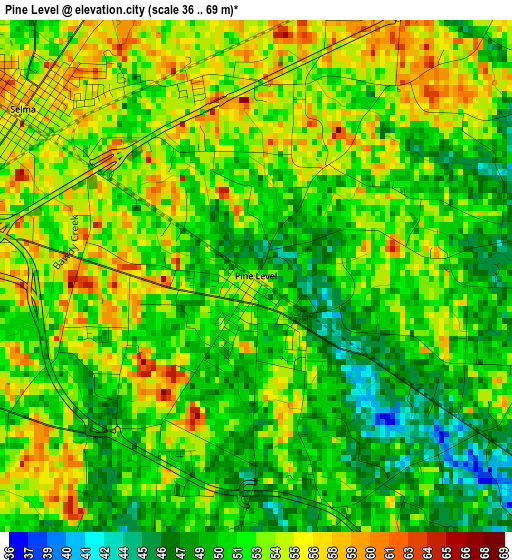
Below is the Elevation map of Pine Level, which displays elevation range with different colors. Scale of the first map is from 36 to 69 m (118 to 226 ft) with average elevation of 52.1 meters (=171 ft) [note 1]
These maps also provides idea of topography and contour of this city, they are displayed at different zoom levels. More info about maps, scale and edge coordinates you can find below images.
| \ | Map #1 | Topo.Map |
| Scale [m] | 36..69 m | × |
| Scale [ft] | 118..226 ft | × |
| Average | 52.1 m = 171 ft | × |
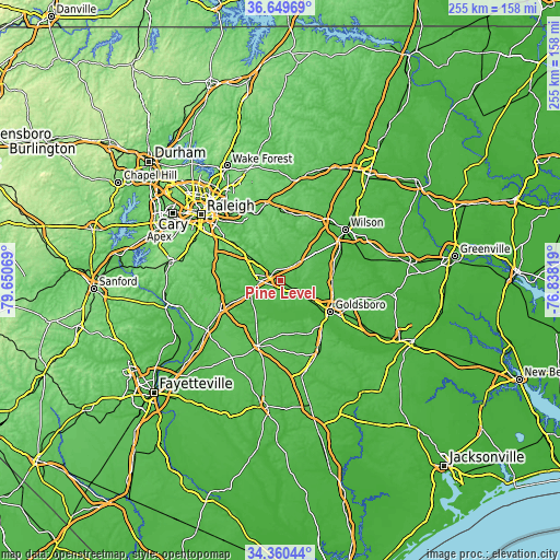
| Width | 7.95 km = 4.9 mi | 254.5 km = 158.1 mi |
| Height | 7.95 km = 4.9 mi | 254.5 km = 158.1 mi |
| ↑Max Latitude | 35.548983° | 36.64969° |
| Latitude at center | 35.51322° | 35.51322° |
| ↓Min Latitude | 35.477441° | 34.36044° |
| ← Min Longitude | -78.288385° | -79.65069° |
| Longitude center | -78.24444° | -78.24444° |
| →Max Longitude | -78.200495° | -76.83819° |
Nearby cities:
Cities around Pine Level sort by population:
• Goldsboro elevation 35 m
26.9 km,  122°
122°
• Clayton 103 m
24.5 km,  308°
308°
• Smithfield 48 m
8.6 km,  266°
266°
• Selma 57 m
4.5 km, 305°
• Archer Lodge 101 m
23.3 km,  329°
329°
• Mar-Mac 35 m
26.2 km,  139°
139°
• Wilsons Mills 71 m
12.8 km, 308°
• Four Oaks 61 m
18.2 km,  245°
245°
• Kenly 63 m
14.3 km,  49°
49°
• Princeton 49 m
9.2 km, 124°
• Fremont 45 m
24.7 km,  81°
81°
• Lucama 41 m
25.8 km,  55°
55°
Multilingual:
 En español:
Pine Level elevación 52 m.
 En France:
Pine Level élévation 52 m.
 Auf Deutsch:
Pine Level höhe über dem Meeresspiegel ist 52 m.

Sources and notes:
- [note 1] Map square and city borders are not equal. Map elevation data is calculated only from area inside that square.
- [src 1] Elevation data from geonames database provided with same terms of usage.
- [src 2] The elevation map of Pine Level is generated using elevation data from NASA's 3 arcsec (90m) resolution SRTM data.
- [src 3] Base (background) map © OpenStreetMap contributors tiles are generated by Geofabrik and OpenTopoMap.
Copyright & License:
This Pine Level Elevation Map is licensed under CC BY-SA. You may reuse any part from this page, if you give a proper credit by linking to this URL:
 More info on terms of use page.