Fremont elevation
Fremont (North Carolina, Wayne County), United States elevation is 45 meters and Fremont elevation in feet is 148 ft above sea level [src 1]. Fremont is a populated place (feature code) with elevation that is 234 meters (768 ft) smaller than average city elevation in United States.
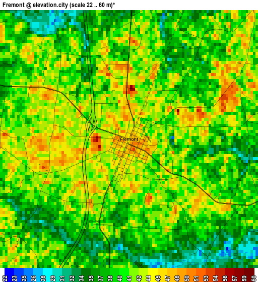
Below is the Elevation map of Fremont, which displays elevation range with different colors. Scale of the first map is from 22 to 60 m (72 to 197 ft) with average elevation of 40.4 meters (=133 ft) [note 1]
These maps also provides idea of topography and contour of this city, they are displayed at different zoom levels. More info about maps, scale and edge coordinates you can find below images.
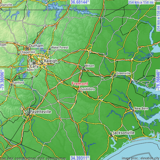
| \ | Map #1 | Topo.Map |
| Scale [m] | 22..60 m | × |
| Scale [ft] | 72..197 ft | × |
| Average | 40.4 m = 133 ft | × |
| Width | 7.95 km = 4.9 mi | 254.4 km = 158.1 mi |
| Height | 7.95 km = 4.9 mi | 254.4 km = 158.1 mi |
| ↑Max Latitude | 35.581188° | 36.68144° |
| Latitude at center | 35.54544° | 35.54544° |
| ↓Min Latitude | 35.509676° | 34.39311° |
| ← Min Longitude | -78.018655° | -79.38096° |
| Longitude center | -77.97471° | -77.97471° |
| →Max Longitude | -77.930765° | -76.56846° |
Nearby cities:
Cities around Fremont sort by population:
• Wilson elevation 40 m
20.3 km,  15°
15°
• Goldsboro 35 m
17.9 km,  185°
185°
• Selma 57 m
28 km,  267°
267°
• Elroy 33 m
23.3 km,  165°
165°
• Mar-Mac 35 m
24.5 km,  197°
197°
• Brogden 55 m
28.6 km, 190°
• Pine Level 52 m
24.7 km,  261°
261°
• Snow Hill 28 m
28.6 km,  111°
111°
• Kenly 63 m
14.7 km,  292°
292°
• Elm City 42 m
30.7 km, 19°
• Princeton 49 m
19 km,  242°
242°
• Lucama 41 m
11.6 km,  344°
344°
Multilingual:
 En español:
Fremont elevación 45 m.
 En France:
Fremont élévation 45 m.


Sources and notes:
- [note 1] Map square and city borders are not equal. Map elevation data is calculated only from area inside that square.
- [src 1] Elevation data from geonames database provided with same terms of usage.
- [src 2] The elevation map of Fremont is generated using elevation data from NASA's 3 arcsec (90m) resolution SRTM data.
- [src 3] Base (background) map © OpenStreetMap contributors tiles are generated by Geofabrik and OpenTopoMap.
Copyright & License:
This Fremont Elevation Map is licensed under CC BY-SA. You may reuse any part from this page, if you give a proper credit by linking to this URL:
 More info on terms of use page.