Maiden elevation
Maiden (North Carolina, Catawba County), United States elevation is 277 meters and Maiden elevation in feet is 909 ft above sea level [src 1]. Maiden is a populated place (feature code) with elevation that is 2 meters (7 ft) smaller than average city elevation in United States.
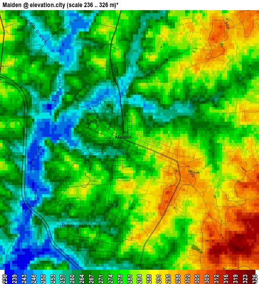
Below is the Elevation map of Maiden, which displays elevation range with different colors. Scale of the first map is from 236 to 326 m (774 to 1070 ft) with average elevation of 274.7 meters (=901 ft) [note 1]
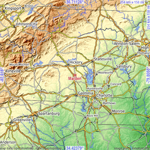
These maps also provides idea of topography and contour of this city, they are displayed at different zoom levels. More info about maps, scale and edge coordinates you can find below images.
| \ | Map #1 | Topo.Map |
| Scale [m] | 236..326 m | × |
| Scale [ft] | 774..1070 ft | × |
| Average | 274.7 m = 901 ft | × |
| Width | 7.95 km = 4.9 mi | 254.3 km = 158 mi |
| Height | 7.95 km = 4.9 mi | 254.3 km = 158 mi |
| ↑Max Latitude | 35.611425° | 36.71126° |
| Latitude at center | 35.57569° | 35.57569° |
| ↓Min Latitude | 35.539939° | 34.42379° |
| ← Min Longitude | -81.255695° | -82.618° |
| Longitude center | -81.21175° | -81.21175° |
| →Max Longitude | -81.167805° | -79.8055° |
Nearby cities:
Cities around Maiden sort by population:
• Hickory elevation 354 m
21.1 km,  326°
326°
• Newton 310 m
10.5 km,  355°
355°
• Lincolnton 259 m
12 km,  198°
198°
• Saint Stephens 340 m
21.7 km,  345°
345°
• Conover 326 m
14.6 km, 357°
• Lake Norman of Catawba 231 m
17.7 km,  88°
88°
• Westport 245 m
22.7 km,  111°
111°
• Mountain View 340 m
18.6 km,  310°
310°
• Denver 276 m
17.2 km, 106°
• Pumpkin Center 290 m
8.9 km,  134°
134°
• Claremont 298 m
16.5 km,  20°
20°
• Sherrills Ford 274 m
21 km,  76°
76°
Multilingual:
 En español:
Maiden elevación 277 m.
 En France:
Maiden élévation 277 m.


Sources and notes:
- [note 1] Map square and city borders are not equal. Map elevation data is calculated only from area inside that square.
- [src 1] Elevation data from geonames database provided with same terms of usage.
- [src 2] The elevation map of Maiden is generated using elevation data from NASA's 3 arcsec (90m) resolution SRTM data.
- [src 3] Base (background) map © OpenStreetMap contributors tiles are generated by Geofabrik and OpenTopoMap.
Copyright & License:
This Maiden Elevation Map is licensed under CC BY-SA. You may reuse any part from this page, if you give a proper credit by linking to this URL:
 More info on terms of use page.