Lincolnton elevation
Lincolnton (North Carolina, Lincoln County), United States elevation is 259 meters and Lincolnton elevation in feet is 850 ft above sea level [src 1]. Lincolnton is a seat of a second-order administrative division (feature code) with elevation that is 20 meters (66 ft) smaller than average city elevation in United States.
Below is the Elevation map of Lincolnton, which displays elevation range with different colors. Scale of the first map is from 224 to 313 m (735 to 1027 ft) with average elevation of 261.4 meters (=858 ft) [note 1]
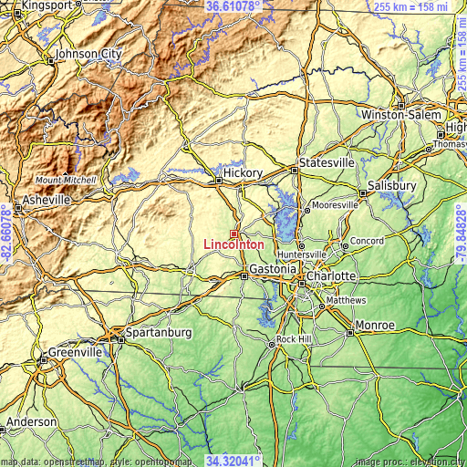
These maps also provides idea of topography and contour of this city, they are displayed at different zoom levels. More info about maps, scale and edge coordinates you can find below images.
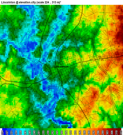
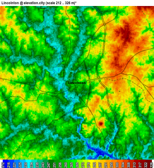
| \ | Map #1 | Map #2 | Topo.Map |
| Scale [m] | 224..313 m | 212..326 m | × |
| Scale [ft] | 735..1027 ft | 696..1070 ft | × |
| Average | 261.4 m = 858 ft | 264.1 m = 866 ft | × |
| Width | 7.96 km = 4.9 mi | 15.92 km = 9.9 mi | 254.7 km = 158.3 mi |
| Height | 7.96 km = 4.9 mi | 15.92 km = 9.9 mi | 254.7 km = 158.3 mi |
| ↑Max Latitude | 35.50953° | 35.545295° | 36.61078° |
| Latitude at center | 35.47375° | 35.47375° | 35.47375° |
| ↓Min Latitude | 35.437954° | 35.402142° | 34.32041° |
| ← Min Longitude | -81.298475° | -81.342421° | -82.66078° |
| Longitude center | -81.25453° | -81.25453° | -81.25453° |
| →Max Longitude | -81.210585° | -81.166639° | -79.84828° |
Nearby cities:
Cities around Lincolnton sort by population:
• Gastonia elevation 249 m
24.3 km,  165°
165°
• Newton 310 m
22 km,  7°
7°
• Cherryville 299 m
15.5 km,  226°
226°
• Bessemer City 278 m
21.2 km,  187°
187°
• Dallas 245 m
18.9 km,  157°
157°
• Stanley 260 m
19.1 km,  131°
131°
• Ranlo 243 m
23.7 km,  151°
151°
• Maiden 277 m
12 km,  18°
18°
• Lowesville 240 m
22.9 km,  105°
105°
• Denver 276 m
21.3 km,  72°
72°
• Pumpkin Center 290 m
11.4 km,  63°
63°
• Tryon 307 m
16.1 km,  202°
202°
Multilingual:
 En español:
Lincolnton elevación 259 m.
 En France:
Lincolnton élévation 259 m.
 Auf Deutsch:
Lincolnton höhe über dem Meeresspiegel ist 259 m.

Sources and notes:
- [note 1] Map square and city borders are not equal. Map elevation data is calculated only from area inside that square.
- [src 1] Elevation data from geonames database provided with same terms of usage.
- [src 2] The elevation map of Lincolnton is generated using elevation data from NASA's 3 arcsec (90m) resolution SRTM data.
- [src 3] Base (background) map © OpenStreetMap contributors tiles are generated by Geofabrik and OpenTopoMap.
Copyright & License:
This Lincolnton Elevation Map is licensed under CC BY-SA. You may reuse any part from this page, if you give a proper credit by linking to this URL:
 More info on terms of use page.