Saint Stephens elevation
Saint Stephens (North Carolina, Catawba County), United States elevation is 340 meters and Saint Stephens elevation in feet is 1115 ft above sea level [src 1]. Saint Stephens is a populated place (feature code) with elevation that is 61 meters (200 ft) bigger than average city elevation in United States.
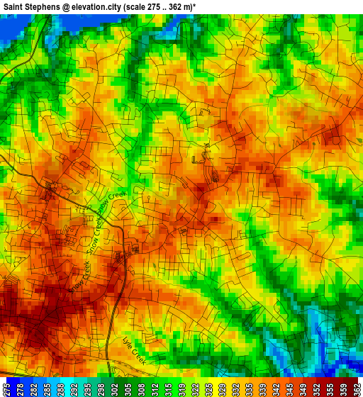
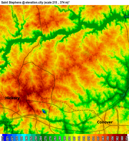
Below is the Elevation map of Saint Stephens, which displays elevation range with different colors. Scale of the first map is from 275 to 362 m (902 to 1188 ft) with average elevation of 327.1 meters (=1073 ft) [note 1]
These maps also provides idea of topography and contour of this city, they are displayed at different zoom levels. More info about maps, scale and edge coordinates you can find below images.
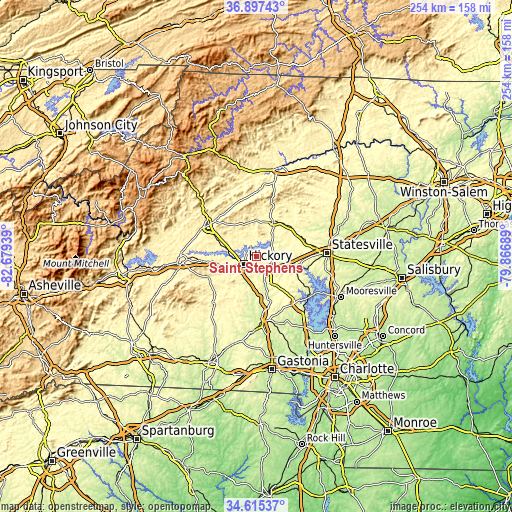
| \ | Map #1 | Map #2 | Topo.Map |
| Scale [m] | 275..362 m | 215..374 m | × |
| Scale [ft] | 902..1188 ft | 705..1227 ft | × |
| Average | 327.1 m = 1073 ft | 315 m = 1033 ft | × |
| Width | 7.93 km = 4.9 mi | 15.86 km = 9.9 mi | 253.7 km = 157.6 mi |
| Height | 7.93 km = 4.9 mi | 15.86 km = 9.9 mi | 253.7 km = 157.6 mi |
| ↑Max Latitude | 35.80023° | 35.835865° | 36.89743° |
| Latitude at center | 35.76458° | 35.76458° | 35.76458° |
| ↓Min Latitude | 35.728914° | 35.693231° | 34.61537° |
| ← Min Longitude | -81.317085° | -81.361031° | -82.67939° |
| Longitude center | -81.27314° | -81.27314° | -81.27314° |
| →Max Longitude | -81.229195° | -81.185249° | -79.86689° |
Nearby cities:
Cities around Saint Stephens sort by population:
• Hickory elevation 354 m
7.1 km,  240°
240°
• Newton 310 m
11.5 km,  156°
156°
• Conover 326 m
8.1 km,  142°
142°
• Longview 348 m
10.7 km,  248°
248°
• Granite Falls 365 m
14.6 km,  284°
284°
• Bethlehem 345 m
7.5 km,  335°
335°
• Mountain View 340 m
12.5 km,  223°
223°
• Icard 366 m
18.3 km,  256°
256°
• Hildebran 355 m
14.6 km, 247°
• Northlakes 292 m
9.4 km, 281°
• Claremont 298 m
12.7 km,  115°
115°
• Rhodhiss 298 m
14.3 km,  274°
274°
Multilingual:
 En español:
Saint Stephens elevación 340 m.
 En France:
Saint Stephens élévation 340 m.
 Auf Deutsch:
Saint Stephens höhe über dem Meeresspiegel ist 340 m.

Sources and notes:
- [note 1] Map square and city borders are not equal. Map elevation data is calculated only from area inside that square.
- [src 1] Elevation data from geonames database provided with same terms of usage.
- [src 2] The elevation map of Saint Stephens is generated using elevation data from NASA's 3 arcsec (90m) resolution SRTM data.
- [src 3] Base (background) map © OpenStreetMap contributors tiles are generated by Geofabrik and OpenTopoMap.
Copyright & License:
This Saint Stephens Elevation Map is licensed under CC BY-SA. You may reuse any part from this page, if you give a proper credit by linking to this URL:
 More info on terms of use page.