Fletcher elevation
Fletcher (North Carolina, Henderson County), United States elevation is 649 meters and Fletcher elevation in feet is 2129 ft above sea level [src 1]. Fletcher is a populated place (feature code) with elevation that is 370 meters (1214 ft) bigger than average city elevation in United States.
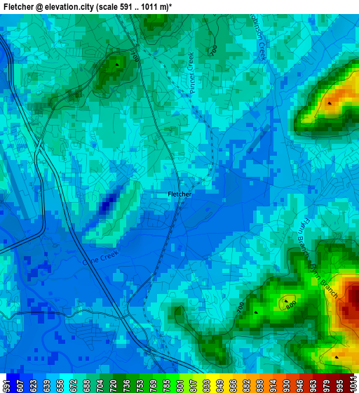
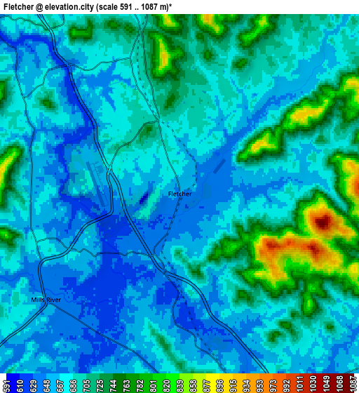
Below is the Elevation map of Fletcher, which displays elevation range with different colors. Scale of the first map is from 591 to 1011 m (1939 to 3317 ft) with average elevation of 673.9 meters (=2211 ft) [note 1]
These maps also provides idea of topography and contour of this city, they are displayed at different zoom levels. More info about maps, scale and edge coordinates you can find below images.
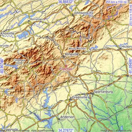
| \ | Map #1 | Map #2 | Topo.Map |
| Scale [m] | 591..1011 m | 591..1087 m | × |
| Scale [ft] | 1939..3317 ft | 1939..3566 ft | × |
| Average | 673.9 m = 2211 ft | 691.3 m = 2268 ft | × |
| Width | 7.96 km = 4.9 mi | 15.93 km = 9.9 mi | 254.8 km = 158.3 mi |
| Height | 7.96 km = 4.9 mi | 15.93 km = 9.9 mi | 254.8 km = 158.3 mi |
| ↑Max Latitude | 35.466469° | 35.502253° | 36.56832° |
| Latitude at center | 35.43067° | 35.43067° | 35.43067° |
| ↓Min Latitude | 35.394855° | 35.359023° | 34.27672° |
| ← Min Longitude | -82.545175° | -82.589121° | -83.90748° |
| Longitude center | -82.50123° | -82.50123° | -82.50123° |
| →Max Longitude | -82.457285° | -82.413339° | -81.09498° |
Nearby cities:
Cities around Fletcher sort by population:
• Hendersonville elevation 664 m
13 km,  163°
163°
• Mills River 643 m
7.6 km,  231°
231°
• Royal Pines 700 m
5.1 km,  344°
344°
• Mountain Home 657 m
6.8 km,  173°
173°
• Horse Shoe 644 m
10.9 km,  207°
207°
• Laurel Park 732 m
13 km,  176°
176°
• Fruitland 678 m
10.5 km,  111°
111°
• Avery Creek 682 m
8.2 km,  296°
296°
• Biltmore Forest 701 m
11.7 km,  347°
347°
• Bent Creek 675 m
13 km,  312°
312°
• Balfour 647 m
9.7 km, 164°
• Hoopers Creek 663 m
3.3 km,  73°
73°
Multilingual:
 En español:
Fletcher elevación 649 m.
 En France:
Fletcher élévation 649 m.
 Auf Deutsch:
Fletcher höhe über dem Meeresspiegel ist 649 m.

Sources and notes:
- [note 1] Map square and city borders are not equal. Map elevation data is calculated only from area inside that square.
- [src 1] Elevation data from geonames database provided with same terms of usage.
- [src 2] The elevation map of Fletcher is generated using elevation data from NASA's 3 arcsec (90m) resolution SRTM data.
- [src 3] Base (background) map © OpenStreetMap contributors tiles are generated by Geofabrik and OpenTopoMap.
Copyright & License:
This Fletcher Elevation Map is licensed under CC BY-SA. You may reuse any part from this page, if you give a proper credit by linking to this URL:
 More info on terms of use page.