Canton elevation
Canton (North Carolina, Haywood County), United States elevation is 803 meters and Canton elevation in feet is 2635 ft above sea level [src 1]. Canton is a populated place (feature code) with elevation that is 524 meters (1719 ft) bigger than average city elevation in United States.
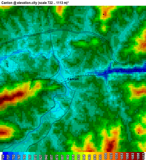
Below is the Elevation map of Canton, which displays elevation range with different colors. Scale of the first map is from 722 to 1113 m (2369 to 3652 ft) with average elevation of 850.5 meters (=2790 ft) [note 1]
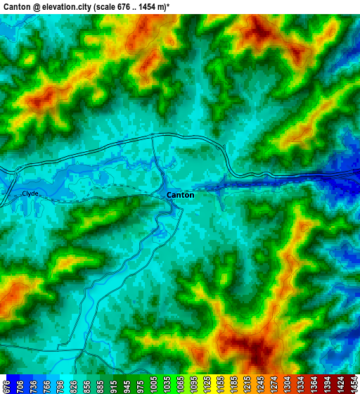
These maps also provides idea of topography and contour of this city, they are displayed at different zoom levels. More info about maps, scale and edge coordinates you can find below images.
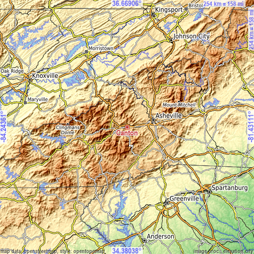
| \ | Map #1 | Map #2 | Topo.Map |
| Scale [m] | 722..1113 m | 676..1454 m | × |
| Scale [ft] | 2369..3652 ft | 2218..4770 ft | × |
| Average | 850.5 m = 2790 ft | 933.5 m = 3063 ft | × |
| Width | 7.95 km = 4.9 mi | 15.91 km = 9.9 mi | 254.5 km = 158.1 mi |
| Height | 7.95 km = 4.9 mi | 15.91 km = 9.9 mi | 254.5 km = 158.1 mi |
| ↑Max Latitude | 35.568634° | 35.604372° | 36.66906° |
| Latitude at center | 35.53288° | 35.53288° | 35.53288° |
| ↓Min Latitude | 35.49711° | 35.461324° | 34.38038° |
| ← Min Longitude | -82.881305° | -82.925251° | -84.24361° |
| Longitude center | -82.83736° | -82.83736° | -82.83736° |
| →Max Longitude | -82.793415° | -82.749469° | -81.43111° |
Nearby cities:
Cities around Canton sort by population:
• Asheville elevation 650 m
26.7 km,  73°
73°
• Waynesville 841 m
14.6 km,  250°
250°
• Woodfin 649 m
25.7 km,  64°
64°
• Lake Junaluska 785 m
11.1 km,  267°
267°
• Avery Creek 682 m
24.3 km,  108°
108°
• Hazelwood 847 m
16.7 km,  244°
244°
• Biltmore Forest 701 m
28 km,  89°
89°
• Bent Creek 675 m
20.9 km,  97°
97°
• Maggie Valley 922 m
23.6 km, 266°
• West Canton 830 m
2 km,  286°
286°
• Clyde 774 m
6.6 km, 270°
• Cove Creek 769 m
17.7 km,  297°
297°
Multilingual:
 En español:
Canton elevación 803 m.
 En France:
Canton élévation 803 m.


Sources and notes:
- [note 1] Map square and city borders are not equal. Map elevation data is calculated only from area inside that square.
- [src 1] Elevation data from geonames database provided with same terms of usage.
- [src 2] The elevation map of Canton is generated using elevation data from NASA's 3 arcsec (90m) resolution SRTM data.
- [src 3] Base (background) map © OpenStreetMap contributors tiles are generated by Geofabrik and OpenTopoMap.
Copyright & License:
This Canton Elevation Map is licensed under CC BY-SA. You may reuse any part from this page, if you give a proper credit by linking to this URL:
 More info on terms of use page.