Asheville elevation
Asheville (North Carolina, Buncombe County), United States elevation is 650 meters and Asheville elevation in feet is 2133 ft above sea level [src 1]. Asheville is a seat of a second-order administrative division (feature code) with elevation that is 371 meters (1217 ft) bigger than average city elevation in United States.
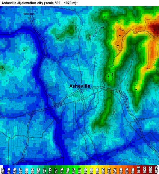
Below is the Elevation map of Asheville, which displays elevation range with different colors. Scale of the first map is from 592 to 1070 m (1942 to 3510 ft) with average elevation of 681.7 meters (=2237 ft) [note 1]
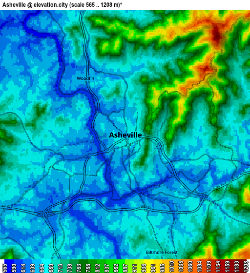
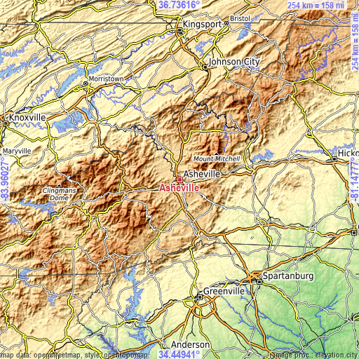
These maps also provides idea of topography and contour of this city, they are displayed at different zoom levels. More info about maps, scale and edge coordinates you can find below images.
| \ | Map #1 | Map #2 | Topo.Map |
| Scale [m] | 592..1070 m | 565..1208 m | × |
| Scale [ft] | 1942..3510 ft | 1854..3963 ft | × |
| Average | 681.7 m = 2237 ft | 706.2 m = 2317 ft | × |
| Width | 7.95 km = 4.9 mi | 15.89 km = 9.9 mi | 254.3 km = 158 mi |
| Height | 7.95 km = 4.9 mi | 15.89 km = 9.9 mi | 254.3 km = 158 mi |
| ↑Max Latitude | 35.636674° | 35.672381° | 36.73616° |
| Latitude at center | 35.60095° | 35.60095° | 35.60095° |
| ↓Min Latitude | 35.56521° | 35.529455° | 34.44941° |
| ← Min Longitude | -82.597965° | -82.641911° | -83.96027° |
| Longitude center | -82.55402° | -82.55402° | -82.55402° |
| →Max Longitude | -82.510075° | -82.466129° | -81.14777° |
Nearby cities:
Cities around Asheville sort by population:
• Black Mountain elevation 733 m
21.1 km,  84°
84°
• Fletcher 649 m
19.5 km,  165°
165°
• Mills River 643 m
23.7 km,  182°
182°
• Woodfin 649 m
4.4 km,  324°
324°
• Swannanoa 675 m
13.9 km,  91°
91°
• Royal Pines 700 m
14.4 km, 166°
• Weaverville 665 m
10.7 km,  356°
356°
• Fairview 685 m
17.3 km,  124°
124°
• Avery Creek 682 m
15.5 km,  189°
189°
• Biltmore Forest 701 m
7.8 km,  162°
162°
• Bent Creek 675 m
11.3 km,  205°
205°
• Hoopers Creek 663 m
19.7 km, 156°
Multilingual:
 En español:
Asheville elevación 650 m.
 En France:
Asheville élévation 650 m.
 Auf Deutsch:
Asheville höhe über dem Meeresspiegel ist 650 m.

Sources and notes:
- [note 1] Map square and city borders are not equal. Map elevation data is calculated only from area inside that square.
- [src 1] Elevation data from geonames database provided with same terms of usage.
- [src 2] The elevation map of Asheville is generated using elevation data from NASA's 3 arcsec (90m) resolution SRTM data.
- [src 3] Base (background) map © OpenStreetMap contributors tiles are generated by Geofabrik and OpenTopoMap.
Copyright & License:
This Asheville Elevation Map is licensed under CC BY-SA. You may reuse any part from this page, if you give a proper credit by linking to this URL:
 More info on terms of use page.