Waynesville elevation
Waynesville (North Carolina, Haywood County), United States elevation is 841 meters and Waynesville elevation in feet is 2759 ft above sea level [src 1]. Waynesville is a seat of a second-order administrative division (feature code) with elevation that is 562 meters (1844 ft) bigger than average city elevation in United States.
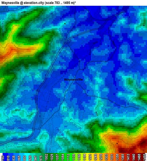
Below is the Elevation map of Waynesville, which displays elevation range with different colors. Scale of the first map is from 783 to 1495 m (2569 to 4905 ft) with average elevation of 920.2 meters (=3019 ft) [note 1]
These maps also provides idea of topography and contour of this city, they are displayed at different zoom levels. More info about maps, scale and edge coordinates you can find below images.
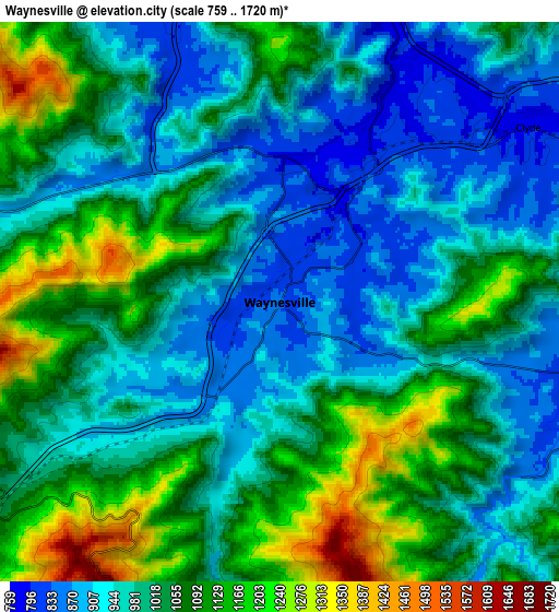
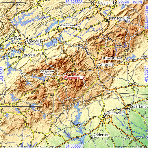
| \ | Map #1 | Map #2 | Topo.Map |
| Scale [m] | 783..1495 m | 759..1720 m | × |
| Scale [ft] | 2569..4905 ft | 2490..5643 ft | × |
| Average | 920.2 m = 3019 ft | 1018.7 m = 3342 ft | × |
| Width | 7.96 km = 4.9 mi | 15.91 km = 9.9 mi | 254.6 km = 158.2 mi |
| Height | 7.96 km = 4.9 mi | 15.91 km = 9.9 mi | 254.6 km = 158.2 mi |
| ↑Max Latitude | 35.524484° | 35.560241° | 36.62553° |
| Latitude at center | 35.48871° | 35.48871° | 35.48871° |
| ↓Min Latitude | 35.45292° | 35.417115° | 34.33558° |
| ← Min Longitude | -83.032695° | -83.076641° | -84.395° |
| Longitude center | -82.98875° | -82.98875° | -82.98875° |
| →Max Longitude | -82.944805° | -82.900859° | -81.5825° |
Nearby cities:
Cities around Waynesville sort by population:
• Brevard elevation 679 m
36.6 km,  140°
140°
• Cullowhee 654 m
25.9 km,  221°
221°
• Canton 803 m
14.6 km,  70°
70°
• Lake Junaluska 785 m
5.1 km,  31°
31°
• Sylva 629 m
25 km,  239°
239°
• Cherokee 603 m
29.6 km,  266°
266°
• Hazelwood 847 m
2.6 km,  211°
211°
• Bent Creek 675 m
34.5 km,  86°
86°
• Maggie Valley 922 m
10.4 km,  288°
288°
• West Canton 830 m
13 km, 65°
• Clyde 774 m
8.6 km,  54°
54°
• Cove Creek 769 m
13.3 km,  351°
351°
Multilingual:
 En español:
Waynesville elevación 841 m.
 En France:
Waynesville élévation 841 m.
 Auf Deutsch:
Waynesville höhe über dem Meeresspiegel ist 841 m.

Sources and notes:
- [note 1] Map square and city borders are not equal. Map elevation data is calculated only from area inside that square.
- [src 1] Elevation data from geonames database provided with same terms of usage.
- [src 2] The elevation map of Waynesville is generated using elevation data from NASA's 3 arcsec (90m) resolution SRTM data.
- [src 3] Base (background) map © OpenStreetMap contributors tiles are generated by Geofabrik and OpenTopoMap.
Copyright & License:
This Waynesville Elevation Map is licensed under CC BY-SA. You may reuse any part from this page, if you give a proper credit by linking to this URL:
 More info on terms of use page.