West Point elevation
West Point (Mississippi, Clay County), United States elevation is 71 meters and West Point elevation in feet is 233 ft above sea level [src 1]. West Point is a seat of a second-order administrative division (feature code) with elevation that is 208 meters (682 ft) smaller than average city elevation in United States.
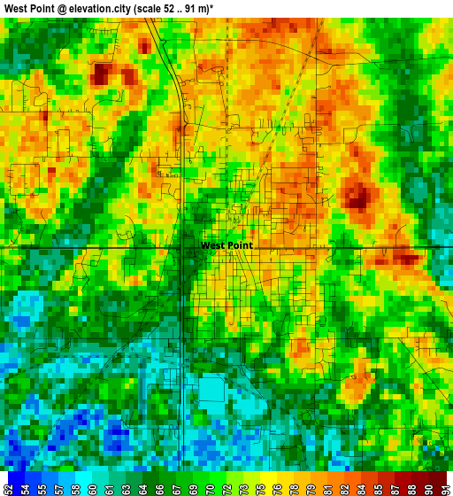
Below is the Elevation map of West Point, which displays elevation range with different colors. Scale of the first map is from 52 to 91 m (171 to 299 ft) with average elevation of 70.1 meters (=230 ft) [note 1]
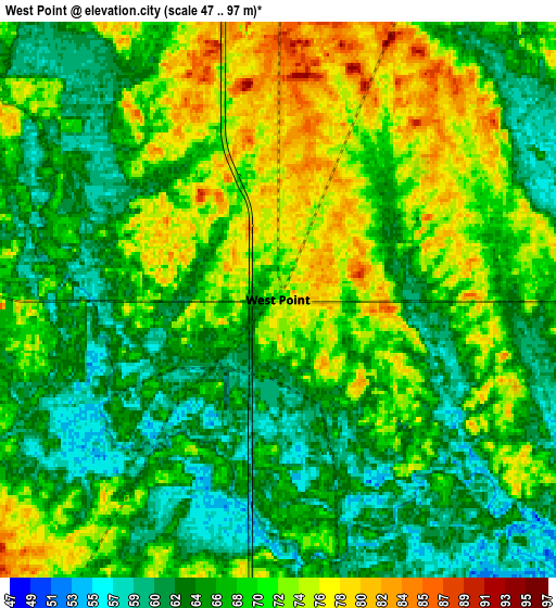
These maps also provides idea of topography and contour of this city, they are displayed at different zoom levels. More info about maps, scale and edge coordinates you can find below images.
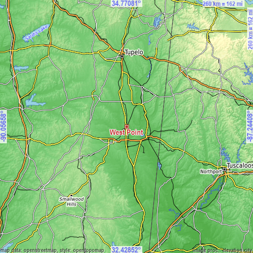
| \ | Map #1 | Map #2 | Topo.Map |
| Scale [m] | 52..91 m | 47..97 m | × |
| Scale [ft] | 171..299 ft | 154..318 ft | × |
| Average | 70.1 m = 230 ft | 68.3 m = 224 ft | × |
| Width | 8.14 km = 5.1 mi | 16.28 km = 10.1 mi | 260.4 km = 161.8 mi |
| Height | 8.14 km = 5.1 mi | 16.28 km = 10.1 mi | 260.4 km = 161.8 mi |
| ↑Max Latitude | 33.644212° | 33.680788° | 34.77081° |
| Latitude at center | 33.60762° | 33.60762° | 33.60762° |
| ↓Min Latitude | 33.571012° | 33.534389° | 32.42852° |
| ← Min Longitude | -88.694275° | -88.738221° | -90.05658° |
| Longitude center | -88.65033° | -88.65033° | -88.65033° |
| →Max Longitude | -88.606385° | -88.562439° | -87.24408° |
Nearby cities:
Cities around West Point sort by population:
• Starkville elevation 104 m
23.5 km,  221°
221°
• Columbus 69 m
24.1 km,  121°
121°
• Amory 76 m
44.5 km,  19°
19°
• Aberdeen 71 m
26.1 km, 22°
• Houston 109 m
45.7 km,  315°
315°
• New Hope 79 m
33.8 km, 117°
• Okolona 104 m
44.9 km,  347°
347°
• Nettleton 80 m
53.6 km,  2°
2°
• Vernon 91 m
52.8 km,  71°
71°
• Columbus Air Force Base 63 m
18.6 km,  81°
81°
• Brooksville 86 m
42 km,  171°
171°
• Caledonia 102 m
31.3 km, 74°
Multilingual:
 En español:
West Point elevación 71 m.
 En France:
West Point élévation 71 m.
 Auf Deutsch:
West Point höhe über dem Meeresspiegel ist 71 m.

Sources and notes:
- [note 1] Map square and city borders are not equal. Map elevation data is calculated only from area inside that square.
- [src 1] Elevation data from geonames database provided with same terms of usage.
- [src 2] The elevation map of West Point is generated using elevation data from NASA's 3 arcsec (90m) resolution SRTM data.
- [src 3] Base (background) map © OpenStreetMap contributors tiles are generated by Geofabrik and OpenTopoMap.
Copyright & License:
This West Point Elevation Map is licensed under CC BY-SA. You may reuse any part from this page, if you give a proper credit by linking to this URL:
 More info on terms of use page.