Houston elevation
Houston (Mississippi, Chickasaw County), United States elevation is 109 meters and Houston elevation in feet is 358 ft above sea level [src 1]. Houston is a populated place (feature code) with elevation that is 170 meters (558 ft) smaller than average city elevation in United States.
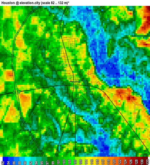
Below is the Elevation map of Houston, which displays elevation range with different colors. Scale of the first map is from 82 to 132 m (269 to 433 ft) with average elevation of 101.4 meters (=333 ft) [note 1]
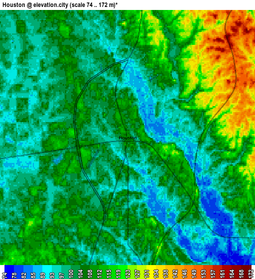
These maps also provides idea of topography and contour of this city, they are displayed at different zoom levels. More info about maps, scale and edge coordinates you can find below images.
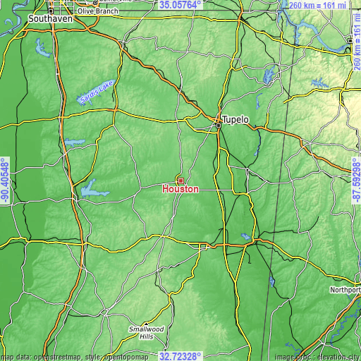
| \ | Map #1 | Map #2 | Topo.Map |
| Scale [m] | 82..132 m | 74..172 m | × |
| Scale [ft] | 269..433 ft | 243..564 ft | × |
| Average | 101.4 m = 333 ft | 106.1 m = 348 ft | × |
| Width | 8.11 km = 5 mi | 16.22 km = 10.1 mi | 259.6 km = 161.3 mi |
| Height | 8.11 km = 5 mi | 16.22 km = 10.1 mi | 259.6 km = 161.3 mi |
| ↑Max Latitude | 33.934918° | 33.97137° | 35.05764° |
| Latitude at center | 33.89845° | 33.89845° | 33.89845° |
| ↓Min Latitude | 33.861966° | 33.825467° | 32.72328° |
| ← Min Longitude | -89.043175° | -89.087121° | -90.40548° |
| Longitude center | -88.99923° | -88.99923° | -88.99923° |
| →Max Longitude | -88.955285° | -88.911339° | -87.59298° |
Nearby cities:
Cities around Houston sort by population:
• Pontotoc elevation 154 m
38.9 km,  0°
0°
• Aberdeen 71 m
42.8 km,  100°
100°
• Verona 99 m
41.8 km,  38°
38°
• Okolona 104 m
25.3 km,  62°
62°
• Nettleton 80 m
40.7 km, 58°
• Bruce 85 m
33.9 km,  287°
287°
• Shannon 80 m
35.9 km,  47°
47°
• Calhoun City 87 m
29.2 km,  260°
260°
• Vardaman 85 m
16.6 km, 261°
• Derma 91 m
26.8 km, 259°
• Pittsboro 120 m
31.6 km,  278°
278°
• Walthall 145 m
41.3 km,  218°
218°
Multilingual:
 En español:
Houston elevación 109 m.
 En France:
Houston élévation 109 m.


Sources and notes:
- [note 1] Map square and city borders are not equal. Map elevation data is calculated only from area inside that square.
- [src 1] Elevation data from geonames database provided with same terms of usage.
- [src 2] The elevation map of Houston is generated using elevation data from NASA's 3 arcsec (90m) resolution SRTM data.
- [src 3] Base (background) map © OpenStreetMap contributors tiles are generated by Geofabrik and OpenTopoMap.
Copyright & License:
This Houston Elevation Map is licensed under CC BY-SA. You may reuse any part from this page, if you give a proper credit by linking to this URL:
 More info on terms of use page.