Walthall elevation
Walthall (Mississippi, Webster County), United States elevation is 145 meters and Walthall elevation in feet is 476 ft above sea level [src 1]. Walthall is a seat of a second-order administrative division (feature code) with elevation that is 134 meters (440 ft) smaller than average city elevation in United States.
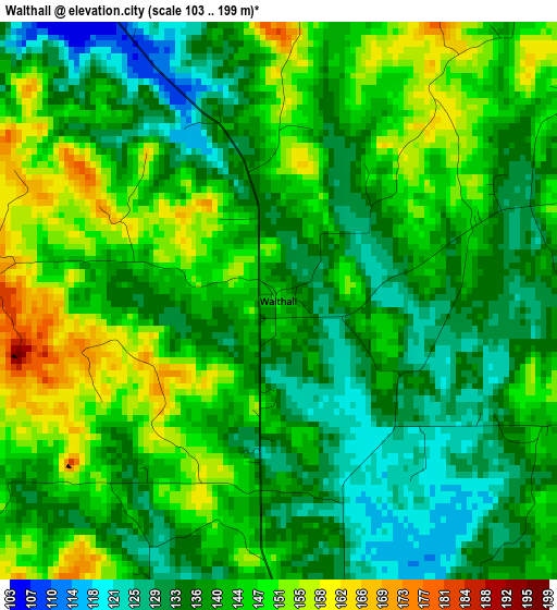
Below is the Elevation map of Walthall, which displays elevation range with different colors. Scale of the first map is from 103 to 199 m (338 to 653 ft) with average elevation of 140.8 meters (=462 ft) [note 1]
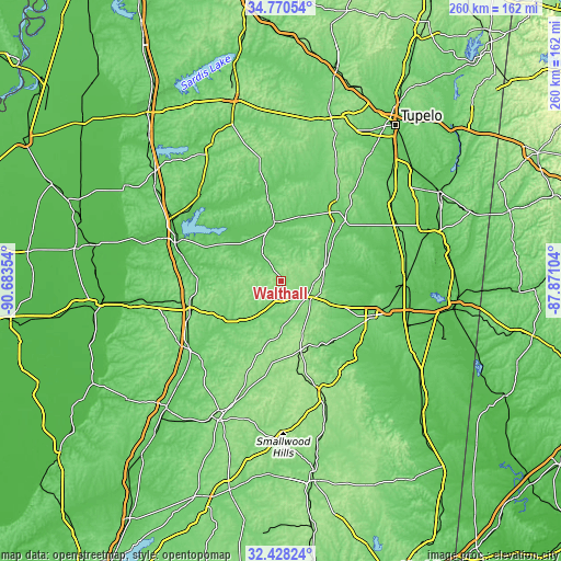
These maps also provides idea of topography and contour of this city, they are displayed at different zoom levels. More info about maps, scale and edge coordinates you can find below images.
| \ | Map #1 | Topo.Map |
| Scale [m] | 103..199 m | × |
| Scale [ft] | 338..653 ft | × |
| Average | 140.8 m = 462 ft | × |
| Width | 8.14 km = 5.1 mi | 260.4 km = 161.8 mi |
| Height | 8.14 km = 5.1 mi | 260.4 km = 161.8 mi |
| ↑Max Latitude | 33.643932° | 34.77054° |
| Latitude at center | 33.60734° | 33.60734° |
| ↓Min Latitude | 33.570732° | 32.42824° |
| ← Min Longitude | -89.321235° | -90.68354° |
| Longitude center | -89.27729° | -89.27729° |
| →Max Longitude | -89.233345° | -87.87104° |
Nearby cities:
Cities around Walthall sort by population:
• Starkville elevation 104 m
45.9 km,  112°
112°
• Grenada 67 m
52.3 km,  290°
290°
• Winona 118 m
44 km,  251°
251°
• Houston 109 m
41.3 km,  38°
38°
• Eupora 119 m
7.5 km,  172°
172°
• Bruce 85 m
43.3 km,  351°
351°
• Calhoun City 87 m
27.8 km, 353°
• Ackerman 158 m
34.4 km,  163°
163°
• Vardaman 85 m
31.2 km,  17°
17°
• Duck Hill 75 m
40.3 km,  274°
274°
• Derma 91 m
27.6 km,  358°
358°
• Pittsboro 120 m
37.4 km, 351°
Multilingual:
 En español:
Walthall elevación 145 m.
 En France:
Walthall élévation 145 m.
 Auf Deutsch:
Walthall höhe über dem Meeresspiegel ist 145 m.

Sources and notes:
- [note 1] Map square and city borders are not equal. Map elevation data is calculated only from area inside that square.
- [src 1] Elevation data from geonames database provided with same terms of usage.
- [src 2] The elevation map of Walthall is generated using elevation data from NASA's 3 arcsec (90m) resolution SRTM data.
- [src 3] Base (background) map © OpenStreetMap contributors tiles are generated by Geofabrik and OpenTopoMap.
Copyright & License:
This Walthall Elevation Map is licensed under CC BY-SA. You may reuse any part from this page, if you give a proper credit by linking to this URL:
 More info on terms of use page.