Senatobia elevation
Senatobia (Mississippi, Tate County), United States elevation is 87 meters and Senatobia elevation in feet is 285 ft above sea level [src 1]. Senatobia is a seat of a second-order administrative division (feature code) with elevation that is 192 meters (630 ft) smaller than average city elevation in United States.
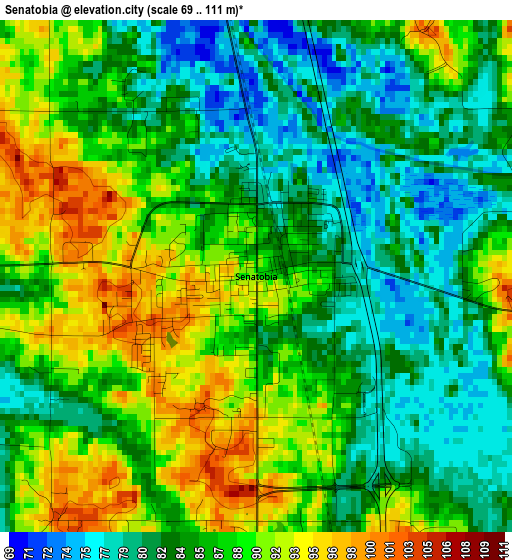
Below is the Elevation map of Senatobia, which displays elevation range with different colors. Scale of the first map is from 69 to 111 m (226 to 364 ft) with average elevation of 86 meters (=282 ft) [note 1]
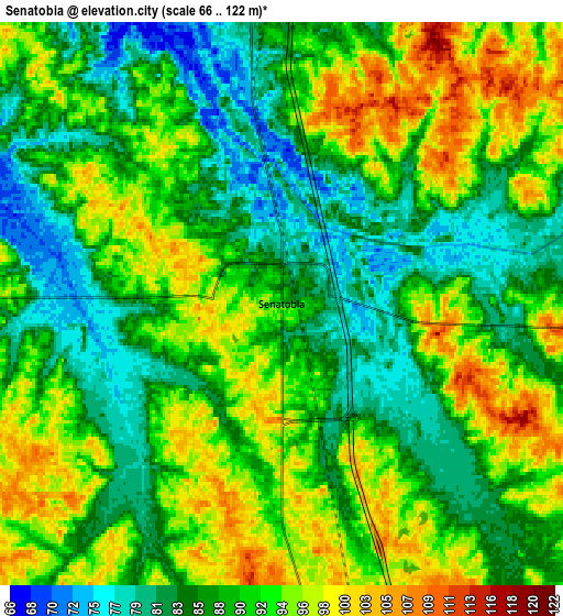
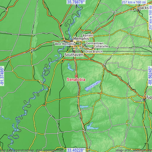
These maps also provides idea of topography and contour of this city, they are displayed at different zoom levels. More info about maps, scale and edge coordinates you can find below images.
| \ | Map #1 | Map #2 | Topo.Map |
| Scale [m] | 69..111 m | 66..122 m | × |
| Scale [ft] | 226..364 ft | 217..400 ft | × |
| Average | 86 m = 282 ft | 89.7 m = 294 ft | × |
| Width | 8.04 km = 5 mi | 16.08 km = 10 mi | 257.3 km = 159.9 mi |
| Height | 8.04 km = 5 mi | 16.08 km = 10 mi | 257.3 km = 159.9 mi |
| ↑Max Latitude | 34.653757° | 34.689899° | 35.76678° |
| Latitude at center | 34.6176° | 34.6176° | 34.6176° |
| ↓Min Latitude | 34.581427° | 34.545238° | 33.45228° |
| ← Min Longitude | -90.012645° | -90.056591° | -91.37495° |
| Longitude center | -89.9687° | -89.9687° | -89.9687° |
| →Max Longitude | -89.924755° | -89.880809° | -88.56245° |
Nearby cities:
Cities around Senatobia sort by population:
• Olive Branch elevation 119 m
40.3 km,  18°
18°
• Horn Lake 89 m
38 km,  350°
350°
• Hernando 117 m
23.1 km, 354°
• Batesville 76 m
34.1 km,  176°
176°
• Lynchburg 93 m
40.1 km,  343°
343°
• Sardis 117 m
20.6 km,  166°
166°
• Coldwater 79 m
8.3 km, 354°
• Walls 67 m
41.4 km, 336°
• Byhalia 111 m
38 km,  41°
41°
• Como 112 m
12.2 km, 167°
• North Tunica 60 m
38.6 km,  283°
283°
• Tunica 63 m
38.6 km, 281°
Multilingual:
 En español:
Senatobia elevación 87 m.
 En France:
Senatobia élévation 87 m.
 Auf Deutsch:
Senatobia höhe über dem Meeresspiegel ist 87 m.

Sources and notes:
- [note 1] Map square and city borders are not equal. Map elevation data is calculated only from area inside that square.
- [src 1] Elevation data from geonames database provided with same terms of usage.
- [src 2] The elevation map of Senatobia is generated using elevation data from NASA's 3 arcsec (90m) resolution SRTM data.
- [src 3] Base (background) map © OpenStreetMap contributors tiles are generated by Geofabrik and OpenTopoMap.
Copyright & License:
This Senatobia Elevation Map is licensed under CC BY-SA. You may reuse any part from this page, if you give a proper credit by linking to this URL:
 More info on terms of use page.