Walls elevation
Walls (Mississippi, De Soto County), United States elevation is 67 meters and Walls elevation in feet is 220 ft above sea level [src 1]. Walls is a populated place (feature code) with elevation that is 212 meters (696 ft) smaller than average city elevation in United States.
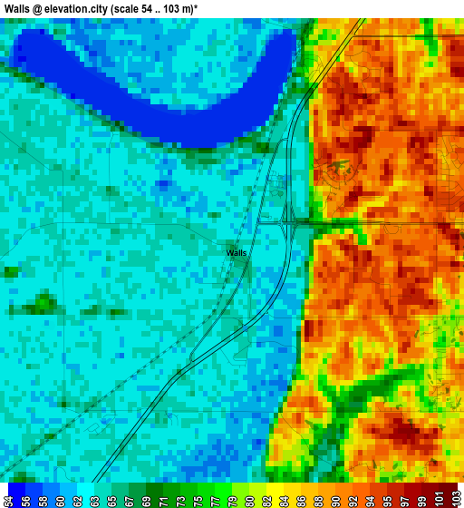
Below is the Elevation map of Walls, which displays elevation range with different colors. Scale of the first map is from 54 to 103 m (177 to 338 ft) with average elevation of 71.4 meters (=234 ft) [note 1]
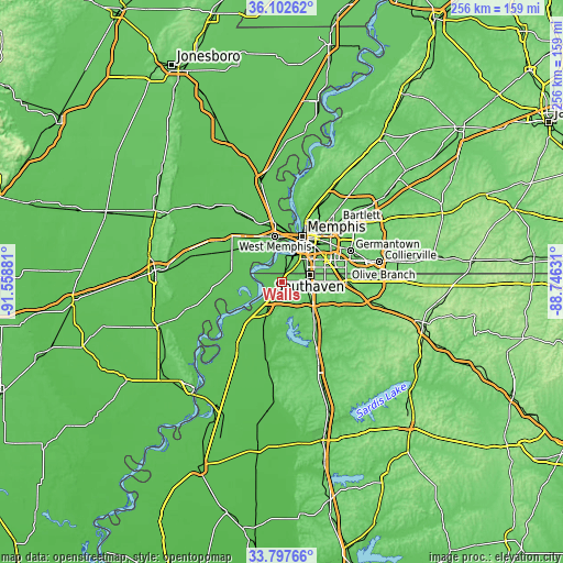
These maps also provides idea of topography and contour of this city, they are displayed at different zoom levels. More info about maps, scale and edge coordinates you can find below images.
| \ | Map #1 | Topo.Map |
| Scale [m] | 54..103 m | × |
| Scale [ft] | 177..338 ft | × |
| Average | 71.4 m = 234 ft | × |
| Width | 8.01 km = 5 mi | 256.3 km = 159.3 mi |
| Height | 8.01 km = 5 mi | 256.3 km = 159.3 mi |
| ↑Max Latitude | 34.994248° | 36.10262° |
| Latitude at center | 34.95824° | 34.95824° |
| ↓Min Latitude | 34.922216° | 33.79766° |
| ← Min Longitude | -90.196505° | -91.55881° |
| Longitude center | -90.15256° | -90.15256° |
| →Max Longitude | -90.108615° | -88.74631° |
Nearby cities:
Cities around Walls sort by population:
• Memphis elevation 84 m
23.3 km,  23°
23°
• New South Memphis 79 m
16.7 km,  31°
31°
• Southaven 95 m
13.2 km,  74°
74°
• Olive Branch 119 m
29.4 km,  89°
89°
• Horn Lake 89 m
10.7 km, 91°
• West Memphis 66 m
21.1 km,  352°
352°
• Hernando 117 m
20.8 km,  135°
135°
• Marion 69 m
28.8 km, 352°
• Lynchburg 93 m
5.2 km,  84°
84°
• Tunica Resorts 65 m
22.3 km,  232°
232°
• Coldwater 79 m
33.7 km,  151°
151°
• Hughes 63 m
29.1 km,  268°
268°
Multilingual:
 En español:
Walls elevación 67 m.
 En France:
Walls élévation 67 m.


Sources and notes:
- [note 1] Map square and city borders are not equal. Map elevation data is calculated only from area inside that square.
- [src 1] Elevation data from geonames database provided with same terms of usage.
- [src 2] The elevation map of Walls is generated using elevation data from NASA's 3 arcsec (90m) resolution SRTM data.
- [src 3] Base (background) map © OpenStreetMap contributors tiles are generated by Geofabrik and OpenTopoMap.
Copyright & License:
This Walls Elevation Map is licensed under CC BY-SA. You may reuse any part from this page, if you give a proper credit by linking to this URL:
 More info on terms of use page.