Tunica Resorts elevation
Tunica Resorts (Mississippi, Tunica County), United States elevation is 65 meters and Tunica Resorts elevation in feet is 213 ft above sea level [src 1]. Tunica Resorts is a populated place (feature code) with elevation that is 214 meters (702 ft) smaller than average city elevation in United States.
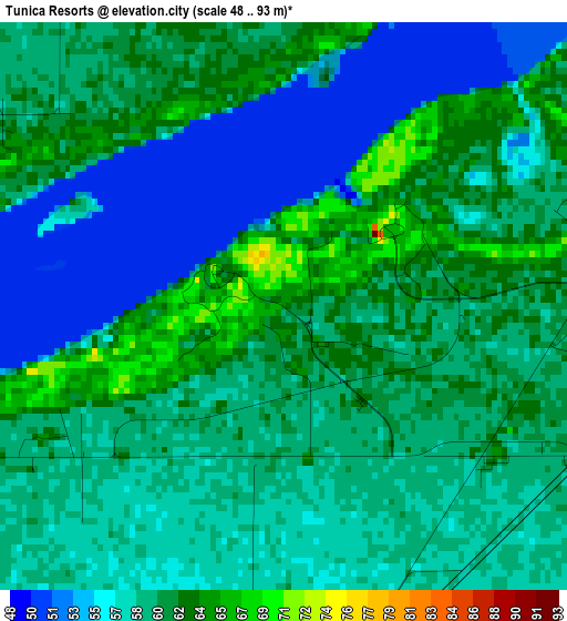
Below is the Elevation map of Tunica Resorts, which displays elevation range with different colors. Scale of the first map is from 48 to 93 m (157 to 305 ft) with average elevation of 59 meters (=194 ft) [note 1]
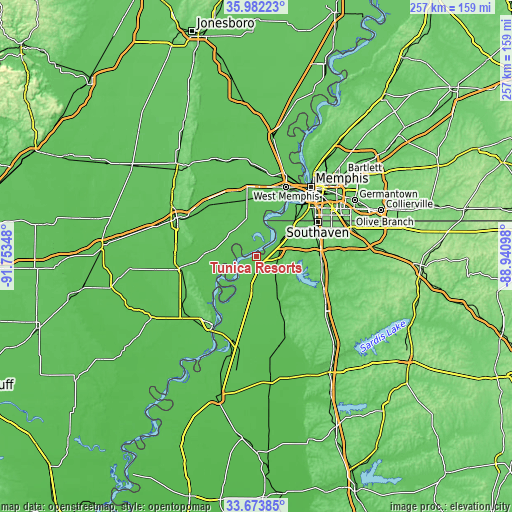
These maps also provides idea of topography and contour of this city, they are displayed at different zoom levels. More info about maps, scale and edge coordinates you can find below images.
| \ | Map #1 | Topo.Map |
| Scale [m] | 48..93 m | × |
| Scale [ft] | 157..305 ft | × |
| Average | 59 m = 194 ft | × |
| Width | 8.02 km = 5 mi | 256.7 km = 159.5 mi |
| Height | 8.02 km = 5 mi | 256.7 km = 159.5 mi |
| ↑Max Latitude | 34.872192° | 35.98223° |
| Latitude at center | 34.83613° | 34.83613° |
| ↓Min Latitude | 34.800052° | 33.67385° |
| ← Min Longitude | -90.391175° | -91.75348° |
| Longitude center | -90.34723° | -90.34723° |
| →Max Longitude | -90.303285° | -88.94098° |
Nearby cities:
Cities around Tunica Resorts sort by population:
• New South Memphis elevation 79 m
38.4 km,  43°
43°
• Southaven 95 m
34.9 km,  60°
60°
• Horn Lake 89 m
31.4 km,  65°
65°
• West Memphis 66 m
37.6 km,  23°
23°
• Hernando 117 m
32.3 km,  92°
92°
• Marianna 71 m
38.1 km,  259°
259°
• Lynchburg 93 m
26.9 km, 58°
• Coldwater 79 m
37.4 km,  115°
115°
• Hughes 63 m
16.9 km,  317°
317°
• Walls 67 m
22.3 km,  52°
52°
• North Tunica 60 m
15.3 km,  190°
190°
• Tunica 63 m
17.2 km, 190°
Multilingual:
 En español:
Tunica Resorts elevación 65 m.
 En France:
Tunica Resorts élévation 65 m.
 Auf Deutsch:
Tunica Resorts höhe über dem Meeresspiegel ist 65 m.

Sources and notes:
- [note 1] Map square and city borders are not equal. Map elevation data is calculated only from area inside that square.
- [src 1] Elevation data from geonames database provided with same terms of usage.
- [src 2] The elevation map of Tunica Resorts is generated using elevation data from NASA's 3 arcsec (90m) resolution SRTM data.
- [src 3] Base (background) map © OpenStreetMap contributors tiles are generated by Geofabrik and OpenTopoMap.
Copyright & License:
This Tunica Resorts Elevation Map is licensed under CC BY-SA. You may reuse any part from this page, if you give a proper credit by linking to this URL:
 More info on terms of use page.