Beechwood elevation
Beechwood (Mississippi, Warren County), United States elevation is 66 meters and Beechwood elevation in feet is 217 ft above sea level [src 1]. Beechwood is a populated place (feature code) with elevation that is 213 meters (699 ft) smaller than average city elevation in United States.
Below is the Elevation map of Beechwood, which displays elevation range with different colors. Scale of the first map is from 38 to 123 m (125 to 404 ft) with average elevation of 82.1 meters (=269 ft) [note 1]
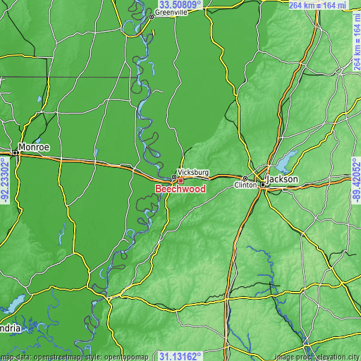
These maps also provides idea of topography and contour of this city, they are displayed at different zoom levels. More info about maps, scale and edge coordinates you can find below images.
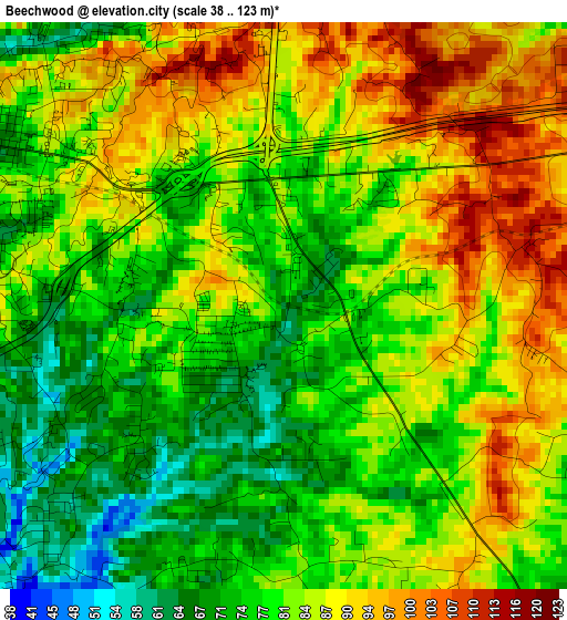
| \ | Map #1 | Topo.Map |
| Scale [m] | 38..123 m | × |
| Scale [ft] | 125..404 ft | × |
| Average | 82.1 m = 269 ft | × |
| Width | 8.26 km = 5.1 mi | 264.2 km = 164.2 mi |
| Height | 8.26 km = 5.1 mi | 264.2 km = 164.2 mi |
| ↑Max Latitude | 32.364776° | 33.50809° |
| Latitude at center | 32.32765° | 32.32765° |
| ↓Min Latitude | 32.290508° | 31.13162° |
| ← Min Longitude | -90.870715° | -92.23302° |
| Longitude center | -90.82677° | -90.82677° |
| →Max Longitude | -90.782825° | -89.42052° |
Nearby cities:
Cities around Beechwood sort by population:
• Clinton elevation 116 m
47.5 km,  88°
88°
• Vicksburg 78 m
5.5 km,  300°
300°
• Byram 81 m
57.1 km,  106°
106°
• Tallulah 30 m
35 km,  284°
284°
• Lynchburg 85 m
28.9 km,  64°
64°
• Raymond 104 m
38.7 km,  101°
101°
• Flora 75 m
54.2 km, 63°
• Port Gibson 39 m
43.4 km,  199°
199°
• Terry 95 m
56.3 km,  117°
117°
• Newellton 29 m
48.2 km,  233°
233°
• Kearney Park 66 m
56.1 km, 58°
• Edwards 72 m
20.8 km, 89°
Multilingual:
 En español:
Beechwood elevación 66 m.
 En France:
Beechwood élévation 66 m.
 Auf Deutsch:
Beechwood höhe über dem Meeresspiegel ist 66 m.

Sources and notes:
- [note 1] Map square and city borders are not equal. Map elevation data is calculated only from area inside that square.
- [src 1] Elevation data from geonames database provided with same terms of usage.
- [src 2] The elevation map of Beechwood is generated using elevation data from NASA's 3 arcsec (90m) resolution SRTM data.
- [src 3] Base (background) map © OpenStreetMap contributors tiles are generated by Geofabrik and OpenTopoMap.
Copyright & License:
This Beechwood Elevation Map is licensed under CC BY-SA. You may reuse any part from this page, if you give a proper credit by linking to this URL:
 More info on terms of use page.