Ashland elevation
Ashland (Mississippi, Benton County), United States elevation is 201 meters and Ashland elevation in feet is 659 ft above sea level [src 1]. Ashland is a seat of a second-order administrative division (feature code) with elevation that is 78 meters (256 ft) smaller than average city elevation in United States.
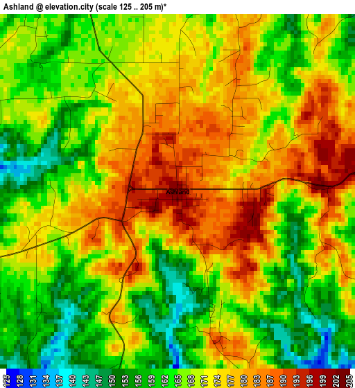
Below is the Elevation map of Ashland, which displays elevation range with different colors. Scale of the first map is from 125 to 205 m (410 to 673 ft) with average elevation of 170.1 meters (=558 ft) [note 1]
These maps also provides idea of topography and contour of this city, they are displayed at different zoom levels. More info about maps, scale and edge coordinates you can find below images.
| \ | Map #1 | Topo.Map |
| Scale [m] | 125..205 m | × |
| Scale [ft] | 410..673 ft | × |
| Average | 170.1 m = 558 ft | × |
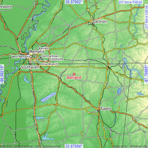
| Width | 8.02 km = 5 mi | 256.7 km = 159.5 mi |
| Height | 8.02 km = 5 mi | 256.7 km = 159.5 mi |
| ↑Max Latitude | 34.868933° | 35.97902° |
| Latitude at center | 34.83287° | 34.83287° |
| ↓Min Latitude | 34.796791° | 33.67054° |
| ← Min Longitude | -89.219845° | -90.58215° |
| Longitude center | -89.1759° | -89.1759° |
| →Max Longitude | -89.131955° | -87.76965° |
Nearby cities:
Cities around Ashland sort by population:
• Collierville elevation 117 m
50.2 km,  297°
297°
• New Albany 111 m
40.7 km,  157°
157°
• Booneville 159 m
58.9 km,  109°
109°
• Holly Springs 186 m
25.9 km,  253°
253°
• Oakland 113 m
53.8 km,  324°
324°
• Ripley 152 m
23.5 km,  119°
119°
• Bolivar 136 m
50.1 km,  19°
19°
• Whiteville 150 m
54.9 km,  2°
2°
• Somerville 122 m
48.4 km,  340°
340°
• Hickory Withe 126 m
59.2 km, 320°
• Piperton 112 m
47 km, 300°
• Byhalia 111 m
47.2 km,  275°
275°
Multilingual:
 En español:
Ashland elevación 201 m.
 En France:
Ashland élévation 201 m.


Sources and notes:
- [note 1] Map square and city borders are not equal. Map elevation data is calculated only from area inside that square.
- [src 1] Elevation data from geonames database provided with same terms of usage.
- [src 2] The elevation map of Ashland is generated using elevation data from NASA's 3 arcsec (90m) resolution SRTM data.
- [src 3] Base (background) map © OpenStreetMap contributors tiles are generated by Geofabrik and OpenTopoMap.
Copyright & License:
This Ashland Elevation Map is licensed under CC BY-SA. You may reuse any part from this page, if you give a proper credit by linking to this URL:
 More info on terms of use page.