Whiteville elevation
Whiteville (Tennessee, Hardeman County), United States elevation is 150 meters and Whiteville elevation in feet is 492 ft above sea level [src 1]. Whiteville is a populated place (feature code) with elevation that is 129 meters (423 ft) smaller than average city elevation in United States.
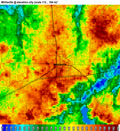
Below is the Elevation map of Whiteville, which displays elevation range with different colors. Scale of the first map is from 112 to 164 m (367 to 538 ft) with average elevation of 142.4 meters (=467 ft) [note 1]
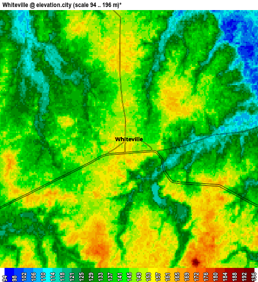
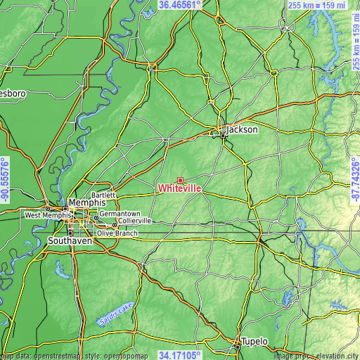
These maps also provides idea of topography and contour of this city, they are displayed at different zoom levels. More info about maps, scale and edge coordinates you can find below images.
| \ | Map #1 | Map #2 | Topo.Map |
| Scale [m] | 112..164 m | 94..196 m | × |
| Scale [ft] | 367..538 ft | 308..643 ft | × |
| Average | 142.4 m = 467 ft | 139.4 m = 457 ft | × |
| Width | 7.97 km = 5 mi | 15.95 km = 9.9 mi | 255.1 km = 158.5 mi |
| Height | 7.97 km = 5 mi | 15.95 km = 9.9 mi | 255.1 km = 158.5 mi |
| ↑Max Latitude | 35.362316° | 35.398146° | 36.46561° |
| Latitude at center | 35.32647° | 35.32647° | 35.32647° |
| ↓Min Latitude | 35.290608° | 35.254731° | 34.17105° |
| ← Min Longitude | -89.193455° | -89.237401° | -90.55576° |
| Longitude center | -89.14951° | -89.14951° | -89.14951° |
| →Max Longitude | -89.105565° | -89.061619° | -87.74326° |
Nearby cities:
Cities around Whiteville sort by population:
• Jackson elevation 126 m
44.1 km,  43°
43°
• Arlington 87 m
46.6 km,  265°
265°
• Brownsville 117 m
31.4 km,  341°
341°
• Covington 105 m
52.2 km,  300°
300°
• Oakland 113 m
34.9 km,  251°
251°
• Henderson 137 m
47.7 km,  74°
74°
• Bolivar 136 m
16.6 km,  118°
118°
• Somerville 122 m
20.4 km,  243°
243°
• Hickory Withe 126 m
40.9 km,  257°
257°
• Alamo 110 m
51 km,  3°
3°
• Bells 100 m
43.1 km,  7°
7°
• Mason 95 m
36 km,  285°
285°
Multilingual:
 En español:
Whiteville elevación 150 m.
 En France:
Whiteville élévation 150 m.
 Auf Deutsch:
Whiteville höhe über dem Meeresspiegel ist 150 m.

Sources and notes:
- [note 1] Map square and city borders are not equal. Map elevation data is calculated only from area inside that square.
- [src 1] Elevation data from geonames database provided with same terms of usage.
- [src 2] The elevation map of Whiteville is generated using elevation data from NASA's 3 arcsec (90m) resolution SRTM data.
- [src 3] Base (background) map © OpenStreetMap contributors tiles are generated by Geofabrik and OpenTopoMap.
Copyright & License:
This Whiteville Elevation Map is licensed under CC BY-SA. You may reuse any part from this page, if you give a proper credit by linking to this URL:
 More info on terms of use page.