Van Buren elevation
Van Buren (Missouri, Carter County), United States elevation is 145 meters and Van Buren elevation in feet is 476 ft above sea level [src 1]. Van Buren is a seat of a second-order administrative division (feature code) with elevation that is 134 meters (440 ft) smaller than average city elevation in United States.
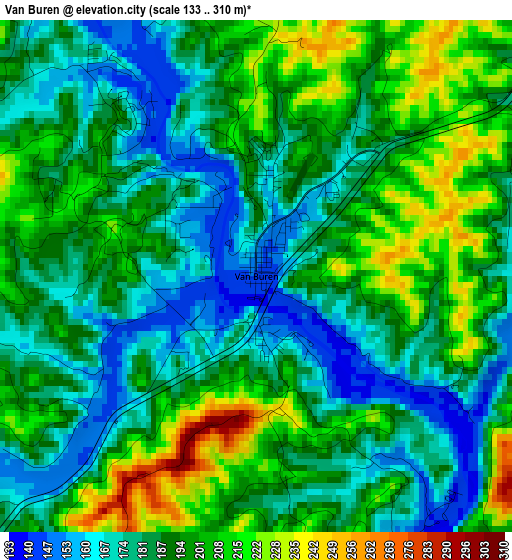
Below is the Elevation map of Van Buren, which displays elevation range with different colors. Scale of the first map is from 133 to 310 m (436 to 1017 ft) with average elevation of 190.5 meters (=625 ft) [note 1]
These maps also provides idea of topography and contour of this city, they are displayed at different zoom levels. More info about maps, scale and edge coordinates you can find below images.
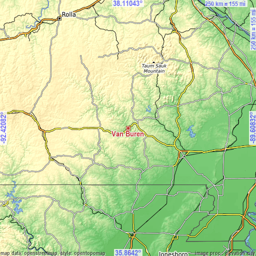
| \ | Map #1 | Topo.Map |
| Scale [m] | 133..310 m | × |
| Scale [ft] | 436..1017 ft | × |
| Average | 190.5 m = 625 ft | × |
| Width | 7.81 km = 4.9 mi | 249.8 km = 155.2 mi |
| Height | 7.81 km = 4.9 mi | 249.8 km = 155.2 mi |
| ↑Max Latitude | 37.0307° | 38.11043° |
| Latitude at center | 36.99561° | 36.99561° |
| ↓Min Latitude | 36.960504° | 35.8642° |
| ← Min Longitude | -91.058515° | -92.42082° |
| Longitude center | -91.01457° | -91.01457° |
| →Max Longitude | -90.970625° | -89.60832° |
Nearby cities:
Cities around Van Buren sort by population:
• Poplar Bluff elevation 116 m
61.3 km,  115°
115°
• Corning 89 m
76 km,  149°
149°
• Mountain View 349 m
61.2 km,  269°
269°
• Thayer 167 m
70.1 km,  221°
221°
• Doniphan 122 m
45 km,  157°
157°
• Piedmont 153 m
33.4 km,  58°
58°
• Ironton 281 m
75.2 km,  27°
27°
• Winona 282 m
27.5 km, 273°
• Alton 242 m
47.9 km,  225°
225°
• Eminence 207 m
35 km,  299°
299°
• Greenville 126 m
52.2 km,  73°
73°
• Centerville 228 m
49.1 km,  5°
5°
Multilingual:
 En español:
Van Buren elevación 145 m.
 En France:
Van Buren élévation 145 m.
 Auf Deutsch:
Van Buren höhe über dem Meeresspiegel ist 145 m.

Sources and notes:
- [note 1] Map square and city borders are not equal. Map elevation data is calculated only from area inside that square.
- [src 1] Elevation data from geonames database provided with same terms of usage.
- [src 2] The elevation map of Van Buren is generated using elevation data from NASA's 3 arcsec (90m) resolution SRTM data.
- [src 3] Base (background) map © OpenStreetMap contributors tiles are generated by Geofabrik and OpenTopoMap.
Copyright & License:
This Van Buren Elevation Map is licensed under CC BY-SA. You may reuse any part from this page, if you give a proper credit by linking to this URL:
 More info on terms of use page.