Mountain View elevation
Mountain View (Missouri, Howell County), United States elevation is 349 meters and Mountain View elevation in feet is 1145 ft above sea level [src 1]. Mountain View is a populated place (feature code) with elevation that is 70 meters (230 ft) bigger than average city elevation in United States.
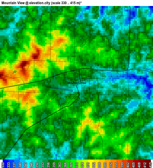
Below is the Elevation map of Mountain View, which displays elevation range with different colors. Scale of the first map is from 330 to 415 m (1083 to 1362 ft) with average elevation of 360.9 meters (=1184 ft) [note 1]
These maps also provides idea of topography and contour of this city, they are displayed at different zoom levels. More info about maps, scale and edge coordinates you can find below images.
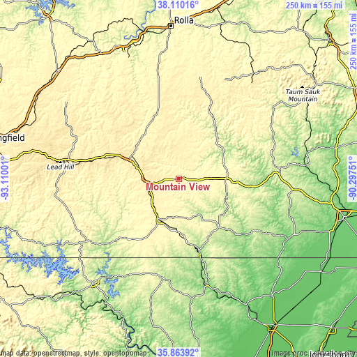
| \ | Map #1 | Topo.Map |
| Scale [m] | 330..415 m | × |
| Scale [ft] | 1083..1362 ft | × |
| Average | 360.9 m = 1184 ft | × |
| Width | 7.81 km = 4.9 mi | 249.8 km = 155.2 mi |
| Height | 7.81 km = 4.9 mi | 249.8 km = 155.2 mi |
| ↑Max Latitude | 37.03042° | 38.11016° |
| Latitude at center | 36.99533° | 36.99533° |
| ↓Min Latitude | 36.960223° | 35.86392° |
| ← Min Longitude | -91.747705° | -93.11001° |
| Longitude center | -91.70376° | -91.70376° |
| →Max Longitude | -91.659815° | -90.29751° |
Nearby cities:
Cities around Mountain View sort by population:
• West Plains elevation 307 m
32.5 km,  203°
203°
• Mountain Grove 453 m
51.9 km,  286°
286°
• Licking 388 m
57.7 km,  346°
346°
• Thayer 167 m
54.4 km,  164°
164°
• Willow Springs 388 m
23.6 km,  269°
269°
• Cabool 395 m
38.1 km, 292°
• Houston 355 m
43 km,  328°
328°
• Salem 202 m
70.2 km,  188°
188°
• Winona 282 m
33.8 km,  87°
87°
• Alton 242 m
43.1 km,  141°
141°
• Van Buren 145 m
61.2 km, 89°
• Eminence 207 m
35.2 km,  60°
60°
Multilingual:
 En español:
Mountain View elevación 349 m.
 En France:
Mountain View élévation 349 m.
 Auf Deutsch:
Mountain View höhe über dem Meeresspiegel ist 349 m.

Sources and notes:
- [note 1] Map square and city borders are not equal. Map elevation data is calculated only from area inside that square.
- [src 1] Elevation data from geonames database provided with same terms of usage.
- [src 2] The elevation map of Mountain View is generated using elevation data from NASA's 3 arcsec (90m) resolution SRTM data.
- [src 3] Base (background) map © OpenStreetMap contributors tiles are generated by Geofabrik and OpenTopoMap.
Copyright & License:
This Mountain View Elevation Map is licensed under CC BY-SA. You may reuse any part from this page, if you give a proper credit by linking to this URL:
 More info on terms of use page.