Piedmont elevation
Piedmont (Missouri, Wayne County), United States elevation is 153 meters and Piedmont elevation in feet is 502 ft above sea level [src 1]. Piedmont is a populated place (feature code) with elevation that is 126 meters (413 ft) smaller than average city elevation in United States.
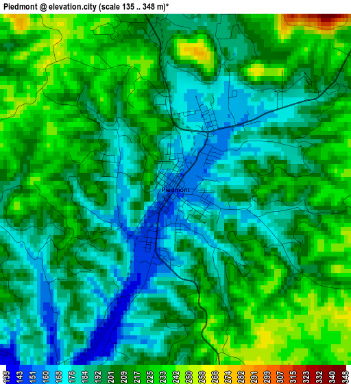
Below is the Elevation map of Piedmont, which displays elevation range with different colors. Scale of the first map is from 135 to 348 m (443 to 1142 ft) with average elevation of 202.6 meters (=665 ft) [note 1]
These maps also provides idea of topography and contour of this city, they are displayed at different zoom levels. More info about maps, scale and edge coordinates you can find below images.
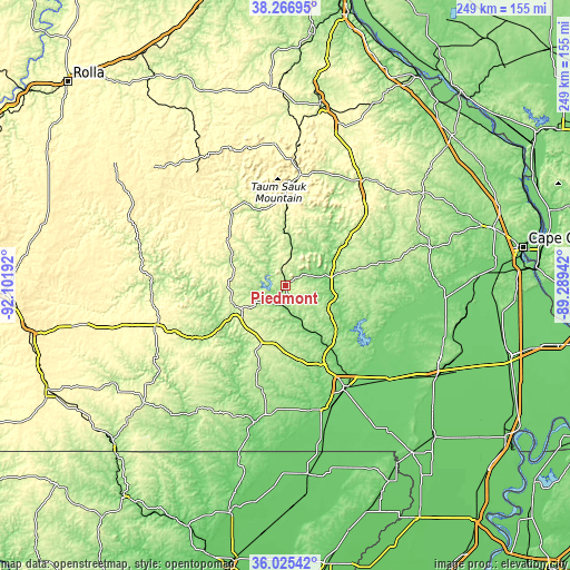
| \ | Map #1 | Topo.Map |
| Scale [m] | 135..348 m | × |
| Scale [ft] | 443..1142 ft | × |
| Average | 202.6 m = 665 ft | × |
| Width | 7.79 km = 4.8 mi | 249.2 km = 154.8 mi |
| Height | 7.79 km = 4.8 mi | 249.2 km = 154.8 mi |
| ↑Max Latitude | 37.189507° | 38.26695° |
| Latitude at center | 37.15449° | 37.15449° |
| ↓Min Latitude | 37.119457° | 36.02542° |
| ← Min Longitude | -90.739615° | -92.10192° |
| Longitude center | -90.69567° | -90.69567° |
| →Max Longitude | -90.651725° | -89.28942° |
Nearby cities:
Cities around Piedmont sort by population:
• Poplar Bluff elevation 116 m
51.7 km,  148°
148°
• Fredericktown 227 m
57.4 km,  38°
38°
• Doniphan 122 m
60.4 km,  190°
190°
• Bismarck 314 m
68.6 km,  5°
5°
• Marble Hill 155 m
66.4 km,  75°
75°
• Ironton 281 m
49.6 km, 6°
• Advance 108 m
69.9 km,  94°
94°
• Winona 282 m
58 km,  253°
253°
• Van Buren 145 m
33.4 km,  238°
238°
• Eminence 207 m
58.7 km,  269°
269°
• Greenville 126 m
22 km,  97°
97°
• Centerville 228 m
38.9 km,  323°
323°
Multilingual:
 En español:
Piedmont elevación 153 m.
 En France:
Piedmont élévation 153 m.
 Auf Deutsch:
Piedmont höhe über dem Meeresspiegel ist 153 m.

Sources and notes:
- [note 1] Map square and city borders are not equal. Map elevation data is calculated only from area inside that square.
- [src 1] Elevation data from geonames database provided with same terms of usage.
- [src 2] The elevation map of Piedmont is generated using elevation data from NASA's 3 arcsec (90m) resolution SRTM data.
- [src 3] Base (background) map © OpenStreetMap contributors tiles are generated by Geofabrik and OpenTopoMap.
Copyright & License:
This Piedmont Elevation Map is licensed under CC BY-SA. You may reuse any part from this page, if you give a proper credit by linking to this URL:
 More info on terms of use page.