Advance elevation
Advance (Missouri, Stoddard County), United States elevation is 108 meters and Advance elevation in feet is 354 ft above sea level [src 1]. Advance is a populated place (feature code) with elevation that is 171 meters (561 ft) smaller than average city elevation in United States.
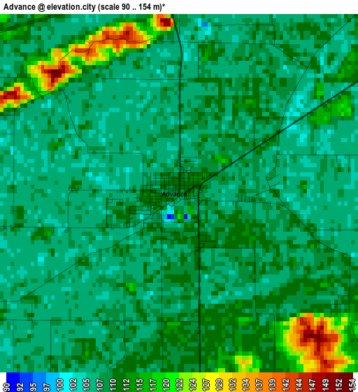
Below is the Elevation map of Advance, which displays elevation range with different colors. Scale of the first map is from 90 to 154 m (295 to 505 ft) with average elevation of 109.4 meters (=359 ft) [note 1]
These maps also provides idea of topography and contour of this city, they are displayed at different zoom levels. More info about maps, scale and edge coordinates you can find below images.
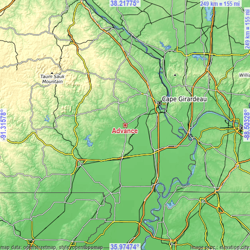
| \ | Map #1 | Topo.Map |
| Scale [m] | 90..154 m | × |
| Scale [ft] | 295..505 ft | × |
| Average | 109.4 m = 359 ft | × |
| Width | 7.79 km = 4.8 mi | 249.4 km = 155 mi |
| Height | 7.79 km = 4.8 mi | 249.4 km = 155 mi |
| ↑Max Latitude | 37.13959° | 38.21775° |
| Latitude at center | 37.10455° | 37.10455° |
| ↓Min Latitude | 37.069494° | 35.97474° |
| ← Min Longitude | -89.953475° | -91.31578° |
| Longitude center | -89.90953° | -89.90953° |
| →Max Longitude | -89.865585° | -88.50328° |
Nearby cities:
Cities around Advance sort by population:
• Cape Girardeau elevation 108 m
41.3 km,  57°
57°
• Sikeston 101 m
38.2 km,  131°
131°
• Jackson 142 m
37.6 km,  34°
34°
• Dexter 116 m
34.6 km,  187°
187°
• Scott City 112 m
36.3 km,  69°
69°
• Chaffee 104 m
24.1 km, 69°
• Bernie 91 m
48.7 km, 186°
• Bloomfield 148 m
24.4 km,  184°
184°
• Marble Hill 155 m
23 km,  346°
346°
• Oran 103 m
22.6 km,  95°
95°
• Benton 134 m
30.8 km,  91°
91°
• Greenville 126 m
48 km,  273°
273°
Multilingual:
 En español:
Advance elevación 108 m.
 En France:
Advance élévation 108 m.


Sources and notes:
- [note 1] Map square and city borders are not equal. Map elevation data is calculated only from area inside that square.
- [src 1] Elevation data from geonames database provided with same terms of usage.
- [src 2] The elevation map of Advance is generated using elevation data from NASA's 3 arcsec (90m) resolution SRTM data.
- [src 3] Base (background) map © OpenStreetMap contributors tiles are generated by Geofabrik and OpenTopoMap.
Copyright & License:
This Advance Elevation Map is licensed under CC BY-SA. You may reuse any part from this page, if you give a proper credit by linking to this URL:
 More info on terms of use page.