Bloomfield elevation
Bloomfield (Missouri, Stoddard County), United States elevation is 148 meters and Bloomfield elevation in feet is 486 ft above sea level [src 1]. Bloomfield is a seat of a second-order administrative division (feature code) with elevation that is 131 meters (430 ft) smaller than average city elevation in United States.
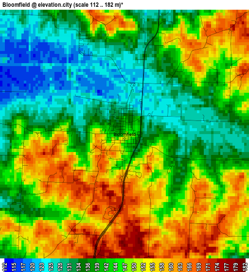
Below is the Elevation map of Bloomfield, which displays elevation range with different colors. Scale of the first map is from 112 to 182 m (367 to 597 ft) with average elevation of 144.3 meters (=473 ft) [note 1]
These maps also provides idea of topography and contour of this city, they are displayed at different zoom levels. More info about maps, scale and edge coordinates you can find below images.
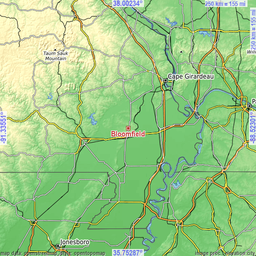
| \ | Map #1 | Topo.Map |
| Scale [m] | 112..182 m | × |
| Scale [ft] | 367..597 ft | × |
| Average | 144.3 m = 473 ft | × |
| Width | 7.82 km = 4.9 mi | 250.1 km = 155.4 mi |
| Height | 7.82 km = 4.9 mi | 250.1 km = 155.4 mi |
| ↑Max Latitude | 36.921031° | 38.00234° |
| Latitude at center | 36.88589° | 36.88589° |
| ↓Min Latitude | 36.850733° | 35.75287° |
| ← Min Longitude | -89.973205° | -91.33551° |
| Longitude center | -89.92926° | -89.92926° |
| →Max Longitude | -89.885315° | -88.52301° |
Nearby cities:
Cities around Bloomfield sort by population:
• Poplar Bluff elevation 116 m
43.7 km,  250°
250°
• Sikeston 101 m
30.4 km,  91°
91°
• Dexter 116 m
10.3 km,  194°
194°
• Malden 90 m
36.7 km, 185°
• Chaffee 104 m
40.8 km,  36°
36°
• Bernie 91 m
24.4 km, 188°
• Campbell 96 m
45.5 km,  196°
196°
• Marble Hill 155 m
46.8 km,  355°
355°
• Advance 108 m
24.4 km,  4°
4°
• Oran 103 m
32.9 km,  47°
47°
• Lilbourn 86 m
43 km,  139°
139°
• Benton 134 m
40.2 km, 54°
Multilingual:
 En español:
Bloomfield elevación 148 m.
 En France:
Bloomfield élévation 148 m.
 Auf Deutsch:
Bloomfield höhe über dem Meeresspiegel ist 148 m.

Sources and notes:
- [note 1] Map square and city borders are not equal. Map elevation data is calculated only from area inside that square.
- [src 1] Elevation data from geonames database provided with same terms of usage.
- [src 2] The elevation map of Bloomfield is generated using elevation data from NASA's 3 arcsec (90m) resolution SRTM data.
- [src 3] Base (background) map © OpenStreetMap contributors tiles are generated by Geofabrik and OpenTopoMap.
Copyright & License:
This Bloomfield Elevation Map is licensed under CC BY-SA. You may reuse any part from this page, if you give a proper credit by linking to this URL:
 More info on terms of use page.