Dexter elevation
Dexter (Missouri, Stoddard County), United States elevation is 116 meters and Dexter elevation in feet is 381 ft above sea level [src 1]. Dexter is a populated place (feature code) with elevation that is 163 meters (535 ft) smaller than average city elevation in United States.
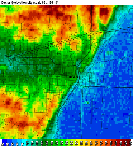
Below is the Elevation map of Dexter, which displays elevation range with different colors. Scale of the first map is from 83 to 176 m (272 to 577 ft) with average elevation of 117.9 meters (=387 ft) [note 1]
These maps also provides idea of topography and contour of this city, they are displayed at different zoom levels. More info about maps, scale and edge coordinates you can find below images.
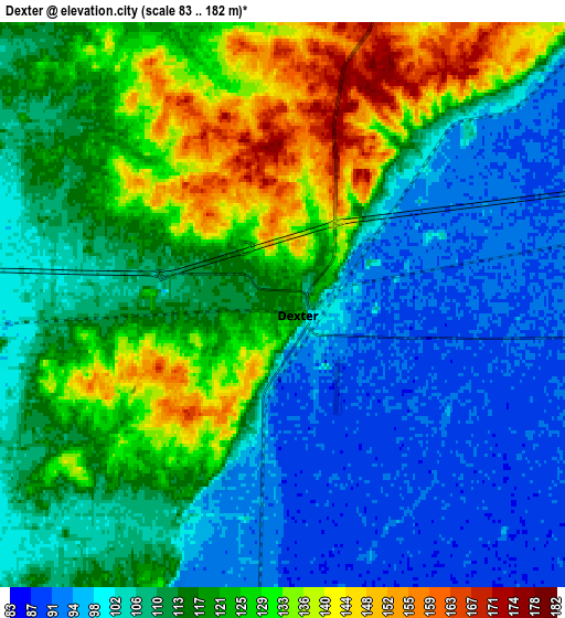
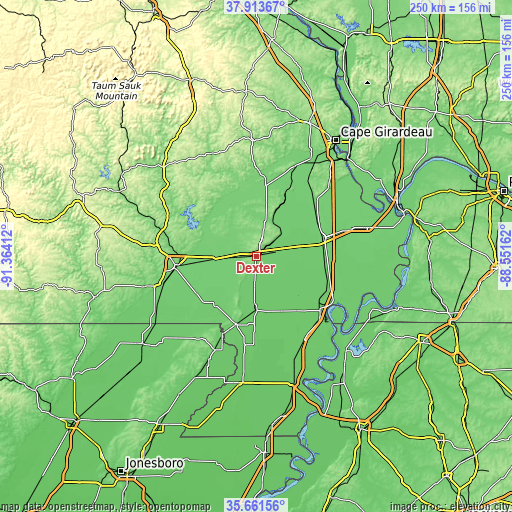
| \ | Map #1 | Map #2 | Topo.Map |
| Scale [m] | 83..176 m | 83..182 m | × |
| Scale [ft] | 272..577 ft | 272..597 ft | × |
| Average | 117.9 m = 387 ft | 113.6 m = 373 ft | × |
| Width | 7.83 km = 4.9 mi | 15.65 km = 9.7 mi | 250.4 km = 155.6 mi |
| Height | 7.83 km = 4.9 mi | 15.65 km = 9.7 mi | 250.4 km = 155.6 mi |
| ↑Max Latitude | 36.831072° | 36.866238° | 37.91367° |
| Latitude at center | 36.79589° | 36.79589° | 36.79589° |
| ↓Min Latitude | 36.760692° | 36.725477° | 35.66156° |
| ← Min Longitude | -90.001815° | -90.045761° | -91.36412° |
| Longitude center | -89.95787° | -89.95787° | -89.95787° |
| →Max Longitude | -89.913925° | -89.869979° | -88.55162° |
Nearby cities:
Cities around Dexter sort by population:
• Poplar Bluff elevation 116 m
39 km,  263°
263°
• Sikeston 101 m
34.1 km,  74°
74°
• Malden 90 m
26.6 km,  181°
181°
• New Madrid 91 m
44.9 km,  121°
121°
• Bernie 91 m
14.1 km, 183°
• Campbell 96 m
35.2 km,  197°
197°
• Bloomfield 148 m
10.3 km,  14°
14°
• Advance 108 m
34.6 km, 7°
• Oran 103 m
41.9 km,  39°
39°
• Clarkton 91 m
38.3 km, 181°
• Lilbourn 86 m
38 km,  126°
126°
• Gideon 82 m
38.4 km,  174°
174°
Multilingual:
 En español:
Dexter elevación 116 m.
 En France:
Dexter élévation 116 m.


Sources and notes:
- [note 1] Map square and city borders are not equal. Map elevation data is calculated only from area inside that square.
- [src 1] Elevation data from geonames database provided with same terms of usage.
- [src 2] The elevation map of Dexter is generated using elevation data from NASA's 3 arcsec (90m) resolution SRTM data.
- [src 3] Base (background) map © OpenStreetMap contributors tiles are generated by Geofabrik and OpenTopoMap.
Copyright & License:
This Dexter Elevation Map is licensed under CC BY-SA. You may reuse any part from this page, if you give a proper credit by linking to this URL:
 More info on terms of use page.