Steelville elevation
Steelville (Missouri, Crawford County), United States elevation is 231 meters and Steelville elevation in feet is 758 ft above sea level [src 1]. Steelville is a seat of a second-order administrative division (feature code) with elevation that is 48 meters (157 ft) smaller than average city elevation in United States.
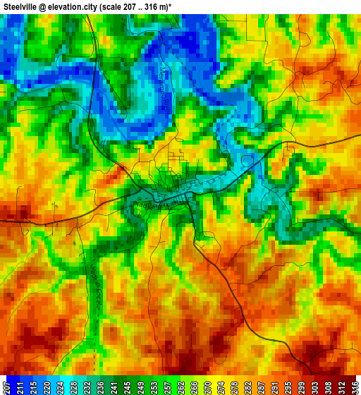
Below is the Elevation map of Steelville, which displays elevation range with different colors. Scale of the first map is from 207 to 316 m (679 to 1037 ft) with average elevation of 265.5 meters (=871 ft) [note 1]
These maps also provides idea of topography and contour of this city, they are displayed at different zoom levels. More info about maps, scale and edge coordinates you can find below images.
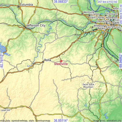
| \ | Map #1 | Topo.Map |
| Scale [m] | 207..316 m | × |
| Scale [ft] | 679..1037 ft | × |
| Average | 265.5 m = 871 ft | × |
| Width | 7.7 km = 4.8 mi | 246.5 km = 153.2 mi |
| Height | 7.7 km = 4.8 mi | 246.5 km = 153.2 mi |
| ↑Max Latitude | 38.002736° | 39.06833° |
| Latitude at center | 37.9681° | 37.9681° |
| ↓Min Latitude | 37.933447° | 36.85114° |
| ← Min Longitude | -91.398815° | -92.76112° |
| Longitude center | -91.35487° | -91.35487° |
| →Max Longitude | -91.310925° | -89.94862° |
Nearby cities:
Cities around Steelville sort by population:
• Rolla elevation 342 m
36.6 km,  267°
267°
• Sullivan 299 m
31.6 km,  32°
32°
• Salem 362 m
39.2 km,  203°
203°
• Saint Clair 238 m
53.2 km,  37°
37°
• Saint James 333 m
23 km,  278°
278°
• Cuba 306 m
11.4 km,  337°
337°
• Potosi 277 m
49.8 km,  94°
94°
• Owensville 292 m
43.9 km, 343°
• Bourbon 291 m
22.9 km, 25°
• Belle 316 m
47.7 km,  317°
317°
• Gerald 277 m
48 km,  2°
2°
• Vienna 266 m
57.3 km,  295°
295°
Multilingual:
 En español:
Steelville elevación 231 m.
 En France:
Steelville élévation 231 m.
 Auf Deutsch:
Steelville höhe über dem Meeresspiegel ist 231 m.

Sources and notes:
- [note 1] Map square and city borders are not equal. Map elevation data is calculated only from area inside that square.
- [src 1] Elevation data from geonames database provided with same terms of usage.
- [src 2] The elevation map of Steelville is generated using elevation data from NASA's 3 arcsec (90m) resolution SRTM data.
- [src 3] Base (background) map © OpenStreetMap contributors tiles are generated by Geofabrik and OpenTopoMap.
Copyright & License:
This Steelville Elevation Map is licensed under CC BY-SA. You may reuse any part from this page, if you give a proper credit by linking to this URL:
 More info on terms of use page.