Salem elevation
Salem (Missouri, Dent County), United States elevation is 362 meters and Salem elevation in feet is 1188 ft above sea level [src 1]. Salem is a seat of a second-order administrative division (feature code) with elevation that is 83 meters (272 ft) bigger than average city elevation in United States.
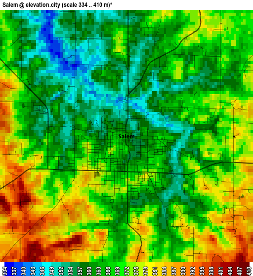
Below is the Elevation map of Salem, which displays elevation range with different colors. Scale of the first map is from 334 to 410 m (1096 to 1345 ft) with average elevation of 368.2 meters (=1208 ft) [note 1]
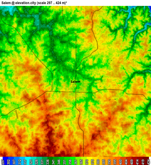
These maps also provides idea of topography and contour of this city, they are displayed at different zoom levels. More info about maps, scale and edge coordinates you can find below images.
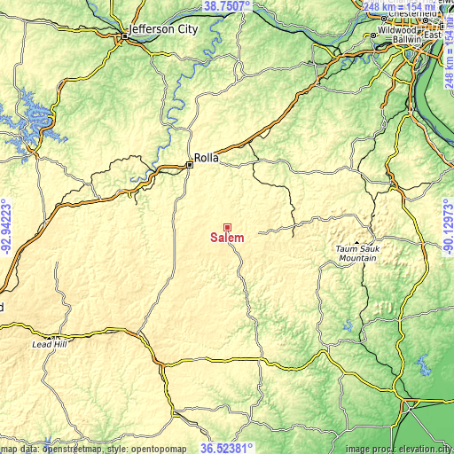
| \ | Map #1 | Map #2 | Topo.Map |
| Scale [m] | 334..410 m | 297..424 m | × |
| Scale [ft] | 1096..1345 ft | 974..1391 ft | × |
| Average | 368.2 m = 1208 ft | 370.7 m = 1216 ft | × |
| Width | 7.74 km = 4.8 mi | 15.48 km = 9.6 mi | 247.6 km = 153.9 mi |
| Height | 7.74 km = 4.8 mi | 15.48 km = 9.6 mi | 247.6 km = 153.9 mi |
| ↑Max Latitude | 37.680388° | 37.71516° | 38.7507° |
| Latitude at center | 37.6456° | 37.6456° | 37.6456° |
| ↓Min Latitude | 37.610796° | 37.575975° | 36.52381° |
| ← Min Longitude | -91.579925° | -91.623871° | -92.94223° |
| Longitude center | -91.53598° | -91.53598° | -91.53598° |
| →Max Longitude | -91.492035° | -91.448089° | -90.12973° |
Nearby cities:
Cities around Salem sort by population:
• Rolla elevation 342 m
39.8 km,  328°
328°
• Fort Leonard Wood 339 m
55.1 km,  276°
276°
• Waynesville 253 m
61.9 km,  289°
289°
• Saint Robert 317 m
60 km, 289°
• Saint James 333 m
39.7 km,  350°
350°
• Cuba 306 m
47.8 km,  14°
14°
• Licking 388 m
32.6 km,  240°
240°
• Houston 355 m
51.3 km,  226°
226°
• Steelville 231 m
39.2 km,  23°
23°
• Bourbon 291 m
62.1 km, 24°
• Eminence 207 m
57.2 km,  164°
164°
• Centerville 228 m
56 km,  114°
114°
Multilingual:
 En español:
Salem elevación 362 m.
 En France:
Salem élévation 362 m.


Sources and notes:
- [note 1] Map square and city borders are not equal. Map elevation data is calculated only from area inside that square.
- [src 1] Elevation data from geonames database provided with same terms of usage.
- [src 2] The elevation map of Salem is generated using elevation data from NASA's 3 arcsec (90m) resolution SRTM data.
- [src 3] Base (background) map © OpenStreetMap contributors tiles are generated by Geofabrik and OpenTopoMap.
Copyright & License:
This Salem Elevation Map is licensed under CC BY-SA. You may reuse any part from this page, if you give a proper credit by linking to this URL:
 More info on terms of use page.