Saint Clair elevation
Saint Clair (Missouri, Franklin County), United States elevation is 238 meters and Saint Clair elevation in feet is 781 ft above sea level [src 1]. Saint Clair is a populated place (feature code) with elevation that is 41 meters (135 ft) smaller than average city elevation in United States.
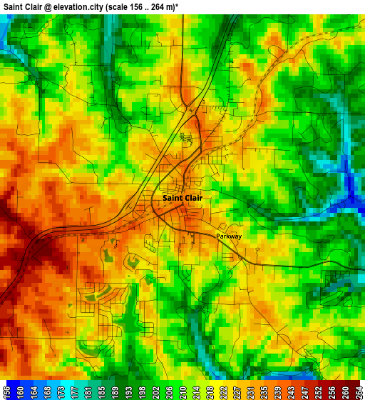
Below is the Elevation map of Saint Clair, which displays elevation range with different colors. Scale of the first map is from 156 to 264 m (512 to 866 ft) with average elevation of 216.1 meters (=709 ft) [note 1]
These maps also provides idea of topography and contour of this city, they are displayed at different zoom levels. More info about maps, scale and edge coordinates you can find below images.
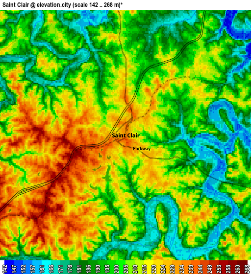
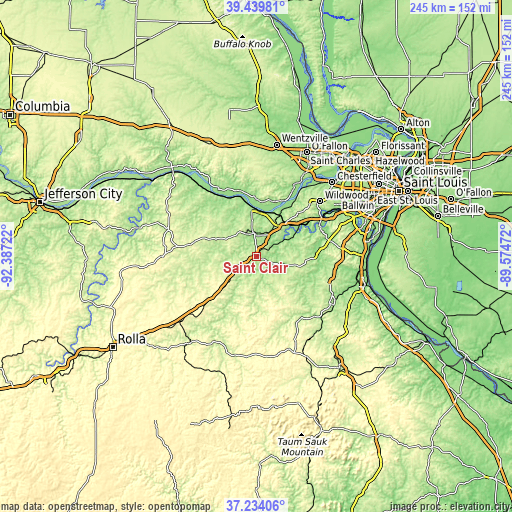
| \ | Map #1 | Map #2 | Topo.Map |
| Scale [m] | 156..264 m | 142..268 m | × |
| Scale [ft] | 512..866 ft | 466..879 ft | × |
| Average | 216.1 m = 709 ft | 203.9 m = 669 ft | × |
| Width | 7.66 km = 4.8 mi | 15.33 km = 9.5 mi | 245.3 km = 152.4 mi |
| Height | 7.66 km = 4.8 mi | 15.33 km = 9.5 mi | 245.3 km = 152.4 mi |
| ↑Max Latitude | 38.379787° | 38.414229° | 39.43981° |
| Latitude at center | 38.34533° | 38.34533° | 38.34533° |
| ↓Min Latitude | 38.310856° | 38.276366° | 37.23406° |
| ← Min Longitude | -91.024915° | -91.068861° | -92.38722° |
| Longitude center | -90.98097° | -90.98097° | -90.98097° |
| →Max Longitude | -90.937025° | -90.893079° | -89.57472° |
Nearby cities:
Cities around Saint Clair sort by population:
• Washington elevation 171 m
23.8 km,  353°
353°
• Union 163 m
11.9 km, 348°
• Eureka 140 m
35.4 km,  60°
60°
• Pacific 141 m
25.8 km,  53°
53°
• Sullivan 299 m
21.9 km,  225°
225°
• Gray Summit 204 m
21.5 km,  41°
41°
• Villa Ridge 204 m
16.4 km,  30°
30°
• Cedar Hill 176 m
29.6 km,  88°
88°
• Bourbon 291 m
31.3 km, 227°
• LaBarque Creek 183 m
27.4 km,  73°
73°
• Gerald 277 m
31.1 km,  281°
281°
• Marthasville 176 m
32.2 km, 348°
Multilingual:
 En español:
Saint Clair elevación 238 m.
 En France:
Saint Clair élévation 238 m.
 Auf Deutsch:
Saint Clair höhe über dem Meeresspiegel ist 238 m.

Sources and notes:
- [note 1] Map square and city borders are not equal. Map elevation data is calculated only from area inside that square.
- [src 1] Elevation data from geonames database provided with same terms of usage.
- [src 2] The elevation map of Saint Clair is generated using elevation data from NASA's 3 arcsec (90m) resolution SRTM data.
- [src 3] Base (background) map © OpenStreetMap contributors tiles are generated by Geofabrik and OpenTopoMap.
Copyright & License:
This Saint Clair Elevation Map is licensed under CC BY-SA. You may reuse any part from this page, if you give a proper credit by linking to this URL:
 More info on terms of use page.