Montgomery City elevation
Montgomery City (Missouri, Montgomery County), United States elevation is 259 meters and Montgomery City elevation in feet is 850 ft above sea level [src 1]. Montgomery City is a seat of a second-order administrative division (feature code) with elevation that is 20 meters (66 ft) smaller than average city elevation in United States.
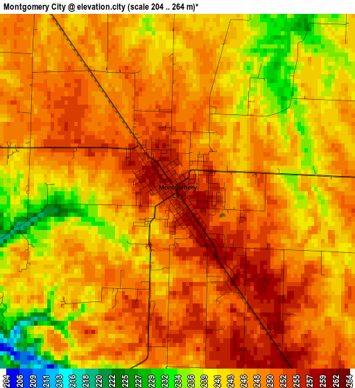
Below is the Elevation map of Montgomery City, which displays elevation range with different colors. Scale of the first map is from 204 to 264 m (669 to 866 ft) with average elevation of 245.9 meters (=807 ft) [note 1]
These maps also provides idea of topography and contour of this city, they are displayed at different zoom levels. More info about maps, scale and edge coordinates you can find below images.
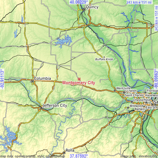
| \ | Map #1 | Topo.Map |
| Scale [m] | 204..264 m | × |
| Scale [ft] | 669..866 ft | × |
| Average | 245.9 m = 807 ft | × |
| Width | 7.6 km = 4.7 mi | 243.1 km = 151.1 mi |
| Height | 7.6 km = 4.7 mi | 243.1 km = 151.1 mi |
| ↑Max Latitude | 39.011695° | 40.06229° |
| Latitude at center | 38.97754° | 38.97754° |
| ↓Min Latitude | 38.943369° | 37.87592° |
| ← Min Longitude | -91.548825° | -92.91113° |
| Longitude center | -91.50488° | -91.50488° |
| →Max Longitude | -91.460935° | -90.09863° |
Nearby cities:
Cities around Montgomery City sort by population:
• Fulton elevation 236 m
41 km,  249°
249°
• Mexico 247 m
39 km,  303°
303°
• Troy 163 m
45.3 km,  89°
89°
• Warrenton 271 m
36.5 km,  120°
120°
• Bowling Green 274 m
48.5 km,  33°
33°
• Vandalia 231 m
37.1 km,  2°
2°
• Wright City 222 m
45.1 km,  111°
111°
• Moscow Mills 162 m
50.8 km, 93°
• Hermann 162 m
30.9 km,  169°
169°
• New Haven 210 m
47.9 km,  148°
148°
• Marthasville 176 m
54.9 km,  135°
135°
• Wellsville 253 m
11.9 km,  331°
331°
Multilingual:
 En español:
Montgomery City elevación 259 m.
 En France:
Montgomery City élévation 259 m.
 Auf Deutsch:
Montgomery City höhe über dem Meeresspiegel ist 259 m.

Sources and notes:
- [note 1] Map square and city borders are not equal. Map elevation data is calculated only from area inside that square.
- [src 1] Elevation data from geonames database provided with same terms of usage.
- [src 2] The elevation map of Montgomery City is generated using elevation data from NASA's 3 arcsec (90m) resolution SRTM data.
- [src 3] Base (background) map © OpenStreetMap contributors tiles are generated by Geofabrik and OpenTopoMap.
Copyright & License:
This Montgomery City Elevation Map is licensed under CC BY-SA. You may reuse any part from this page, if you give a proper credit by linking to this URL:
 More info on terms of use page.