Hermann elevation
Hermann (Missouri, Gasconade County), United States elevation is 162 meters and Hermann elevation in feet is 531 ft above sea level [src 1]. Hermann is a seat of a second-order administrative division (feature code) with elevation that is 117 meters (384 ft) smaller than average city elevation in United States.
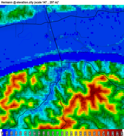
Below is the Elevation map of Hermann, which displays elevation range with different colors. Scale of the first map is from 147 to 297 m (482 to 974 ft) with average elevation of 184.9 meters (=607 ft) [note 1]
These maps also provides idea of topography and contour of this city, they are displayed at different zoom levels. More info about maps, scale and edge coordinates you can find below images.
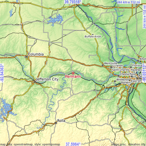
| \ | Map #1 | Topo.Map |
| Scale [m] | 147..297 m | × |
| Scale [ft] | 482..974 ft | × |
| Average | 184.9 m = 607 ft | × |
| Width | 7.63 km = 4.7 mi | 244 km = 151.6 mi |
| Height | 7.63 km = 4.7 mi | 244 km = 151.6 mi |
| ↑Max Latitude | 38.738496° | 39.79318° |
| Latitude at center | 38.70421° | 38.70421° |
| ↓Min Latitude | 38.669908° | 37.5984° |
| ← Min Longitude | -91.481325° | -92.84363° |
| Longitude center | -91.43738° | -91.43738° |
| →Max Longitude | -91.393435° | -90.03113° |
Nearby cities:
Cities around Hermann sort by population:
• Washington elevation 171 m
40.4 km,  113°
113°
• Fulton 236 m
47 km,  289°
289°
• Union 163 m
46.8 km,  127°
127°
• Warrenton 271 m
28.3 km,  65°
65°
• Wright City 222 m
38.7 km, 69°
• Montgomery City 259 m
30.9 km,  349°
349°
• Owensville 292 m
40.3 km,  187°
187°
• New Haven 210 m
21.7 km,  119°
119°
• Linn 265 m
43.3 km,  235°
235°
• Gerald 277 m
35.1 km,  164°
164°
• Marthasville 176 m
34 km,  104°
104°
• Wellsville 253 m
42.5 km,  344°
344°
Multilingual:
 En español:
Hermann elevación 162 m.
 En France:
Hermann élévation 162 m.


Sources and notes:
- [note 1] Map square and city borders are not equal. Map elevation data is calculated only from area inside that square.
- [src 1] Elevation data from geonames database provided with same terms of usage.
- [src 2] The elevation map of Hermann is generated using elevation data from NASA's 3 arcsec (90m) resolution SRTM data.
- [src 3] Base (background) map © OpenStreetMap contributors tiles are generated by Geofabrik and OpenTopoMap.
Copyright & License:
This Hermann Elevation Map is licensed under CC BY-SA. You may reuse any part from this page, if you give a proper credit by linking to this URL:
 More info on terms of use page.