Linn elevation
Linn (Missouri, Osage County), United States elevation is 265 meters and Linn elevation in feet is 869 ft above sea level [src 1]. Linn is a seat of a second-order administrative division (feature code) with elevation that is 14 meters (46 ft) smaller than average city elevation in United States.
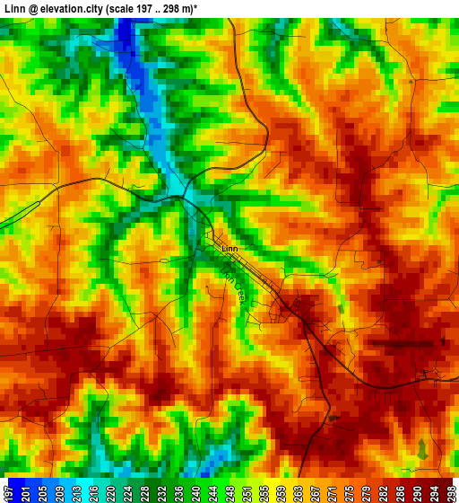
Below is the Elevation map of Linn, which displays elevation range with different colors. Scale of the first map is from 197 to 298 m (646 to 978 ft) with average elevation of 262.2 meters (=860 ft) [note 1]
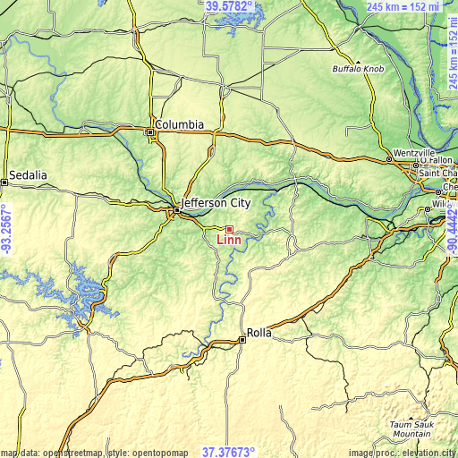
These maps also provides idea of topography and contour of this city, they are displayed at different zoom levels. More info about maps, scale and edge coordinates you can find below images.
| \ | Map #1 | Topo.Map |
| Scale [m] | 197..298 m | × |
| Scale [ft] | 646..978 ft | × |
| Average | 262.2 m = 860 ft | × |
| Width | 7.65 km = 4.8 mi | 244.8 km = 152.1 mi |
| Height | 7.65 km = 4.8 mi | 244.8 km = 152.1 mi |
| ↑Max Latitude | 38.52026° | 39.5782° |
| Latitude at center | 38.48587° | 38.48587° |
| ↓Min Latitude | 38.451463° | 37.37673° |
| ← Min Longitude | -91.894395° | -93.2567° |
| Longitude center | -91.85045° | -91.85045° |
| →Max Longitude | -91.806505° | -90.4442° |
Nearby cities:
Cities around Linn sort by population:
• Jefferson City elevation 195 m
29.9 km,  289°
289°
• Fulton 236 m
41 km,  348°
348°
• Ashland 277 m
47.7 km,  312°
312°
• Holts Summit 259 m
29.2 km, 305°
• Owensville 292 m
34.2 km,  117°
117°
• Hermann 162 m
43.3 km,  55°
55°
• Wardsville 239 m
28.2 km,  270°
270°
• Belle 316 m
25 km,  152°
152°
• Gerald 277 m
46.3 km,  101°
101°
• Saint Martins 236 m
44 km, 285°
• Taos 226 m
19.3 km,  276°
276°
• Vienna 266 m
34.3 km,  194°
194°
Multilingual:
 En español:
Linn elevación 265 m.
 En France:
Linn élévation 265 m.


Sources and notes:
- [note 1] Map square and city borders are not equal. Map elevation data is calculated only from area inside that square.
- [src 1] Elevation data from geonames database provided with same terms of usage.
- [src 2] The elevation map of Linn is generated using elevation data from NASA's 3 arcsec (90m) resolution SRTM data.
- [src 3] Base (background) map © OpenStreetMap contributors tiles are generated by Geofabrik and OpenTopoMap.
Copyright & License:
This Linn Elevation Map is licensed under CC BY-SA. You may reuse any part from this page, if you give a proper credit by linking to this URL:
 More info on terms of use page.