Duenweg elevation
Duenweg (Missouri, Jasper County), United States elevation is 330 meters and Duenweg elevation in feet is 1083 ft above sea level [src 1]. Duenweg is a populated place (feature code) with elevation that is 51 meters (167 ft) bigger than average city elevation in United States.
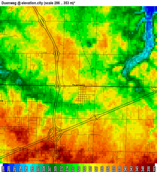
Below is the Elevation map of Duenweg, which displays elevation range with different colors. Scale of the first map is from 286 to 353 m (938 to 1158 ft) with average elevation of 324.6 meters (=1065 ft) [note 1]
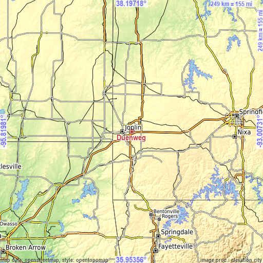
These maps also provides idea of topography and contour of this city, they are displayed at different zoom levels. More info about maps, scale and edge coordinates you can find below images.
| \ | Map #1 | Topo.Map |
| Scale [m] | 286..353 m | × |
| Scale [ft] | 938..1158 ft | × |
| Average | 324.6 m = 1065 ft | × |
| Width | 7.8 km = 4.8 mi | 249.5 km = 155 mi |
| Height | 7.8 km = 4.8 mi | 249.5 km = 155 mi |
| ↑Max Latitude | 37.11872° | 38.19718° |
| Latitude at center | 37.08367° | 37.08367° |
| ↓Min Latitude | 37.048604° | 35.95356° |
| ← Min Longitude | -94.457505° | -95.81981° |
| Longitude center | -94.41356° | -94.41356° |
| →Max Longitude | -94.369615° | -93.00731° |
Nearby cities:
Cities around Duenweg sort by population:
• Joplin elevation 308 m
8.8 km,  270°
270°
• Carthage 309 m
13.8 km,  41°
41°
• Neosho 319 m
24.2 km,  170°
170°
• Webb City 305 m
8.2 km,  327°
327°
• Carl Junction 274 m
17 km,  307°
307°
• Baxter Springs 259 m
29.3 km,  256°
256°
• Galena 274 m
20.1 km, 267°
• Oronogo 280 m
12.7 km,  336°
336°
• Granby 349 m
23.1 km,  142°
142°
• Carterville 301 m
7.7 km, 340°
• Duquesne 329 m
4.1 km, 259°
• Sarcoxie 336 m
26.4 km,  93°
93°
Multilingual:
 En español:
Duenweg elevación 330 m.
 En France:
Duenweg élévation 330 m.


Sources and notes:
- [note 1] Map square and city borders are not equal. Map elevation data is calculated only from area inside that square.
- [src 1] Elevation data from geonames database provided with same terms of usage.
- [src 2] The elevation map of Duenweg is generated using elevation data from NASA's 3 arcsec (90m) resolution SRTM data.
- [src 3] Base (background) map © OpenStreetMap contributors tiles are generated by Geofabrik and OpenTopoMap.
Copyright & License:
This Duenweg Elevation Map is licensed under CC BY-SA. You may reuse any part from this page, if you give a proper credit by linking to this URL:
 More info on terms of use page.